You are here: Home > Network List > CI - Caltech Regional Seismic Network Stations List
> Station VTV Victorville, California, USA > Earthquake Result Viewer
VTV Victorville, California, USA - Earthquake Result Viewer
| Earthquake location: |
Central Alaska |
| Earthquake latitude/longitude: |
63.5/-147.9 |
| Earthquake time(UTC): |
2002/10/23 (296) 11:27:19 GMT |
| Earthquake Depth: |
4.2 km |
| Earthquake Magnitude: |
6.0 MB, 6.7 MS, 6.7 MW, 6.7 MW |
| Earthquake Catalog/Contributor: |
WHDF/NEIC |
|
| Network: |
CI Caltech Regional Seismic Network |
| Station: |
VTV Victorville, California, USA |
| Lat/Lon: |
34.56 N/117.33 W |
| Elevation: |
812 m |
|
| Distance: |
34.6 deg |
| Az: |
132.285 deg |
| Baz: |
336.301 deg |
| Ray Param: |
0.07768127 |
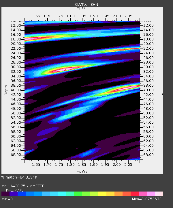
| Estimated Moho Depth: |
30.75 km |
| Estimated Crust Vp/Vs: |
1.78 |
| Assumed Crust Vp: |
6.276 km/s |
| Estimated Crust Vs: |
3.531 km/s |
| Estimated Crust Poisson's Ratio: |
0.27 |
|
| Radial Match: |
84.31349 % |
| Radial Bump: |
262 |
| Transverse Match: |
67.97226 % |
| Transverse Bump: |
400 |
| SOD ConfigId: |
4714 |
| Insert Time: |
2010-03-05 22:18:13.390 +0000 |
| GWidth: |
2.5 |
| Max Bumps: |
400 |
| Tol: |
0.001 |
|

Signal To Noise
| Channel | StoN | STA | LTA |
| CI:VTV: :BHN:20021023T11:33:38.423011Z | 2.5094912 | 9.849111E-7 | 3.9247445E-7 |
| CI:VTV: :BHE:20021023T11:33:38.423011Z | 1.1727457 | 6.775707E-7 | 5.777644E-7 |
| CI:VTV: :BHZ:20021023T11:33:38.423011Z | 3.0537972 | 1.5380733E-6 | 5.036593E-7 |
| Arrivals |
| Ps | 4.1 SECOND |
| PpPs | 13 SECOND |
| PsPs/PpSs | 17 SECOND |


