You are here: Home > Network List > IW - Intermountain West Stations List
> Station PLID Pearl Lake, Idaho, USA > Earthquake Result Viewer
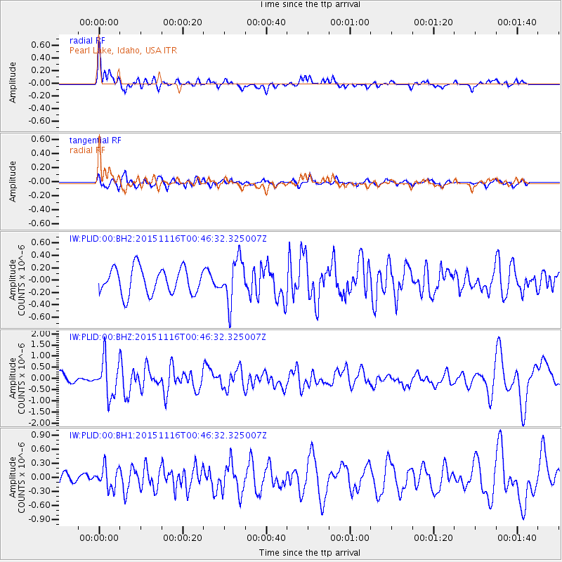
PLID Pearl Lake, Idaho, USA - Earthquake Result Viewer
*The percent match for this event was below the threshold and hence no stack was calculated.
| Earthquake location: |
North Of Honduras |
| Earthquake latitude/longitude: |
17.8/-81.8 |
| Earthquake time(UTC): |
2015/11/16 (320) 00:39:33 GMT |
| Earthquake Depth: |
9.1 km |
| Earthquake Magnitude: |
5.8 MWP |
| Earthquake Catalog/Contributor: |
NEIC PDE/NEIC COMCAT |
|
| Network: |
IW Intermountain West |
| Station: |
PLID Pearl Lake, Idaho, USA |
| Lat/Lon: |
45.09 N/116.00 W |
| Elevation: |
2164 m |
|
| Distance: |
39.3 deg |
| Az: |
321.143 deg |
| Baz: |
122.484 deg |
| Ray Param: |
$rayparam |
*The percent match for this event was below the threshold and hence was not used in the summary stack. |
|
| Radial Match: |
67.375305 % |
| Radial Bump: |
395 |
| Transverse Match: |
66.4704 % |
| Transverse Bump: |
400 |
| SOD ConfigId: |
1259291 |
| Insert Time: |
2015-11-30 01:37:14.397 +0000 |
| GWidth: |
2.5 |
| Max Bumps: |
400 |
| Tol: |
0.001 |
|
Signal To Noise
| Channel | StoN | STA | LTA |
| IW:PLID:00:BHZ:20151116T00:46:32.325007Z | 2.9703908 | 8.4102095E-7 | 2.831348E-7 |
| IW:PLID:00:BH1:20151116T00:46:32.325007Z | 1.2193867 | 2.3139009E-7 | 1.8975939E-7 |
| IW:PLID:00:BH2:20151116T00:46:32.325007Z | 1.6950408 | 3.5591384E-7 | 2.099736E-7 |
| Arrivals |
| Ps | |
| PpPs | |
| PsPs/PpSs | |


