You are here: Home > Network List > CI - Caltech Regional Seismic Network Stations List
> Station VTV Victorville, California, USA > Earthquake Result Viewer
VTV Victorville, California, USA - Earthquake Result Viewer
| Earthquake location: |
Northern Algeria |
| Earthquake latitude/longitude: |
37.0/3.6 |
| Earthquake time(UTC): |
2003/05/21 (141) 18:44:20 GMT |
| Earthquake Depth: |
12 km |
| Earthquake Magnitude: |
6.5 MB, 6.9 MS, 6.8 MW, 6.7 MW |
| Earthquake Catalog/Contributor: |
WHDF/NEIC |
|
| Network: |
CI Caltech Regional Seismic Network |
| Station: |
VTV Victorville, California, USA |
| Lat/Lon: |
34.56 N/117.33 W |
| Elevation: |
812 m |
|
| Distance: |
90.1 deg |
| Az: |
314.953 deg |
| Baz: |
43.378 deg |
| Ray Param: |
0.041696157 |
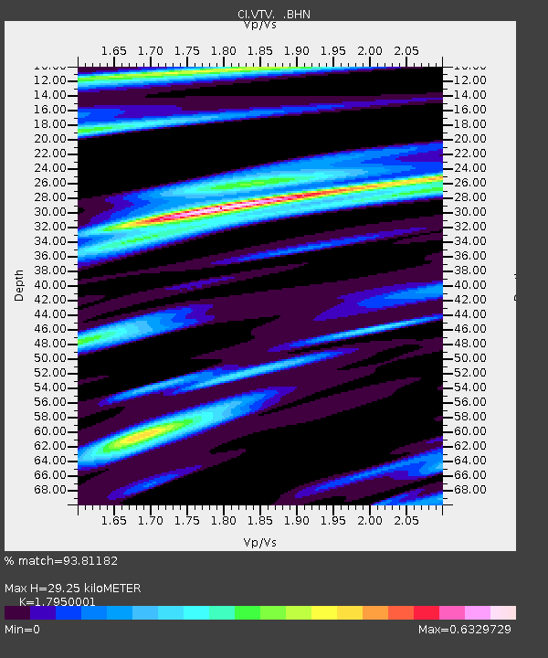
| Estimated Moho Depth: |
29.25 km |
| Estimated Crust Vp/Vs: |
1.80 |
| Assumed Crust Vp: |
6.276 km/s |
| Estimated Crust Vs: |
3.496 km/s |
| Estimated Crust Poisson's Ratio: |
0.27 |
|
| Radial Match: |
93.81182 % |
| Radial Bump: |
400 |
| Transverse Match: |
85.68753 % |
| Transverse Bump: |
400 |
| SOD ConfigId: |
3770 |
| Insert Time: |
2010-03-05 22:18:20.246 +0000 |
| GWidth: |
2.5 |
| Max Bumps: |
400 |
| Tol: |
0.001 |
|

Signal To Noise
| Channel | StoN | STA | LTA |
| CI:VTV: :BHN:20030521T18:56:48.310022Z | 0.9510575 | 4.026839E-7 | 4.2340648E-7 |
| CI:VTV: :BHE:20030521T18:56:48.310022Z | 1.3353689 | 5.970207E-7 | 4.4708298E-7 |
| CI:VTV: :BHZ:20030521T18:56:48.310022Z | 1.696026 | 4.0475777E-7 | 2.3865067E-7 |
| Arrivals |
| Ps | 3.8 SECOND |
| PpPs | 13 SECOND |
| PsPs/PpSs | 17 SECOND |


