You are here: Home > Network List > TA - USArray Transportable Network (new EarthScope stations) Stations List
> Station 121A Cookes Peak, Deming, NM, USA > Earthquake Result Viewer
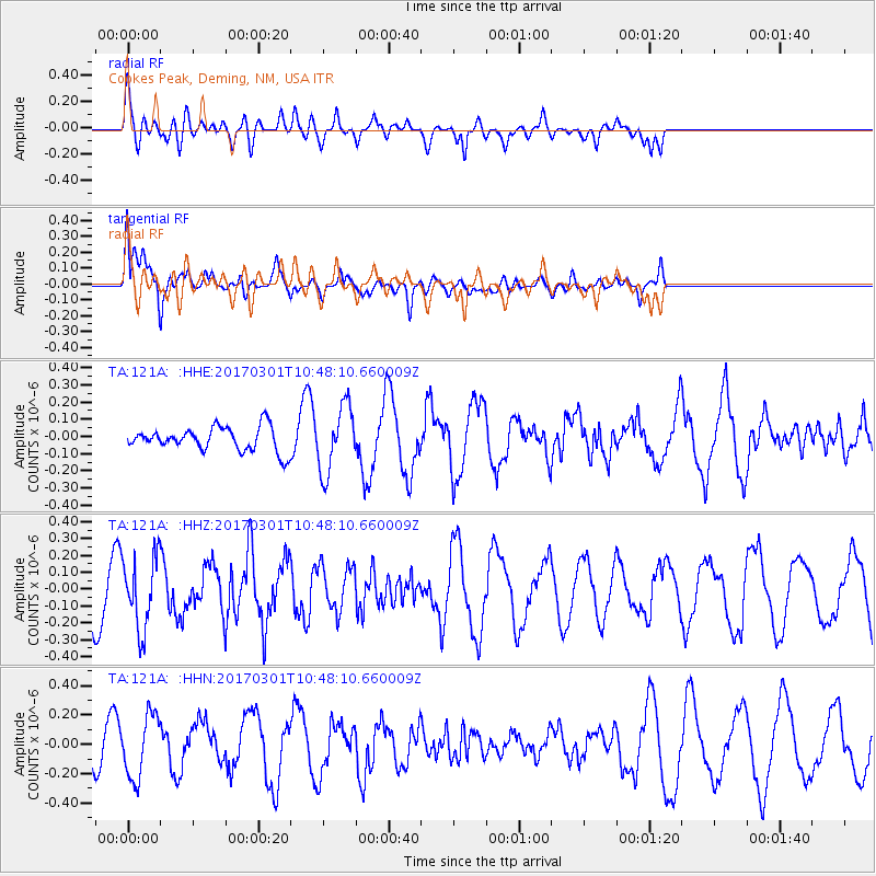
121A Cookes Peak, Deming, NM, USA - Earthquake Result Viewer
*The percent match for this event was below the threshold and hence no stack was calculated.
| Earthquake location: |
Andreanof Islands, Aleutian Is. |
| Earthquake latitude/longitude: |
52.2/-173.4 |
| Earthquake time(UTC): |
2017/03/01 (060) 10:39:49 GMT |
| Earthquake Depth: |
58 km |
| Earthquake Magnitude: |
5.5 mb |
| Earthquake Catalog/Contributor: |
NEIC PDE/us |
|
| Network: |
TA USArray Transportable Network (new EarthScope stations) |
| Station: |
121A Cookes Peak, Deming, NM, USA |
| Lat/Lon: |
32.53 N/107.79 W |
| Elevation: |
1652 m |
|
| Distance: |
50.5 deg |
| Az: |
85.95 deg |
| Baz: |
313.345 deg |
| Ray Param: |
$rayparam |
*The percent match for this event was below the threshold and hence was not used in the summary stack. |
|
| Radial Match: |
49.262096 % |
| Radial Bump: |
400 |
| Transverse Match: |
55.293404 % |
| Transverse Bump: |
400 |
| SOD ConfigId: |
11737051 |
| Insert Time: |
2019-04-26 20:53:15.699 +0000 |
| GWidth: |
2.5 |
| Max Bumps: |
400 |
| Tol: |
0.001 |
|
Signal To Noise
| Channel | StoN | STA | LTA |
| TA:121A: :HHZ:20170301T10:48:10.660009Z | 2.0357604 | 2.08091E-7 | 1.02217825E-7 |
| TA:121A: :HHN:20170301T10:48:10.660009Z | 1.8533102 | 2.1177395E-7 | 1.1426795E-7 |
| TA:121A: :HHE:20170301T10:48:10.660009Z | 2.7952046 | 1.9266987E-7 | 6.892872E-8 |
| Arrivals |
| Ps | |
| PpPs | |
| PsPs/PpSs | |


