You are here: Home > Network List > TA - USArray Transportable Network (new EarthScope stations) Stations List
> Station T25A Trinidad, CO, USA > Earthquake Result Viewer
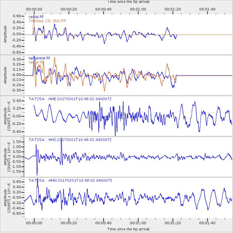
T25A Trinidad, CO, USA - Earthquake Result Viewer
*The percent match for this event was below the threshold and hence no stack was calculated.
| Earthquake location: |
Andreanof Islands, Aleutian Is. |
| Earthquake latitude/longitude: |
52.2/-173.4 |
| Earthquake time(UTC): |
2017/03/01 (060) 10:39:49 GMT |
| Earthquake Depth: |
58 km |
| Earthquake Magnitude: |
5.5 mb |
| Earthquake Catalog/Contributor: |
NEIC PDE/us |
|
| Network: |
TA USArray Transportable Network (new EarthScope stations) |
| Station: |
T25A Trinidad, CO, USA |
| Lat/Lon: |
37.14 N/104.41 W |
| Elevation: |
2017 m |
|
| Distance: |
49.4 deg |
| Az: |
79.063 deg |
| Baz: |
310.829 deg |
| Ray Param: |
$rayparam |
*The percent match for this event was below the threshold and hence was not used in the summary stack. |
|
| Radial Match: |
69.498405 % |
| Radial Bump: |
400 |
| Transverse Match: |
66.19987 % |
| Transverse Bump: |
400 |
| SOD ConfigId: |
11737051 |
| Insert Time: |
2019-04-26 20:53:28.470 +0000 |
| GWidth: |
2.5 |
| Max Bumps: |
400 |
| Tol: |
0.001 |
|
Signal To Noise
| Channel | StoN | STA | LTA |
| TA:T25A: :HHZ:20170301T10:48:02.940007Z | 3.442222 | 5.395921E-7 | 1.5675693E-7 |
| TA:T25A: :HHN:20170301T10:48:02.940007Z | 3.8014395 | 2.805621E-7 | 7.3804166E-8 |
| TA:T25A: :HHE:20170301T10:48:02.940007Z | 1.1829557 | 1.3061212E-7 | 1.10411676E-7 |
| Arrivals |
| Ps | |
| PpPs | |
| PsPs/PpSs | |


