You are here: Home > Network List > TA - USArray Transportable Network (new EarthScope stations) Stations List
> Station WHTX Lake Whitney, Meridian, TX, USA > Earthquake Result Viewer
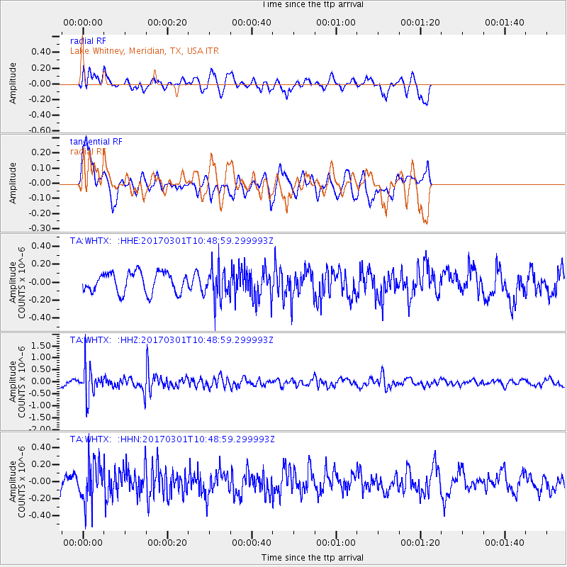
WHTX Lake Whitney, Meridian, TX, USA - Earthquake Result Viewer
*The percent match for this event was below the threshold and hence no stack was calculated.
| Earthquake location: |
Andreanof Islands, Aleutian Is. |
| Earthquake latitude/longitude: |
52.2/-173.4 |
| Earthquake time(UTC): |
2017/03/01 (060) 10:39:49 GMT |
| Earthquake Depth: |
58 km |
| Earthquake Magnitude: |
5.5 mb |
| Earthquake Catalog/Contributor: |
NEIC PDE/us |
|
| Network: |
TA USArray Transportable Network (new EarthScope stations) |
| Station: |
WHTX Lake Whitney, Meridian, TX, USA |
| Lat/Lon: |
31.99 N/97.46 W |
| Elevation: |
190 m |
|
| Distance: |
57.1 deg |
| Az: |
78.9 deg |
| Baz: |
314.667 deg |
| Ray Param: |
$rayparam |
*The percent match for this event was below the threshold and hence was not used in the summary stack. |
|
| Radial Match: |
50.890366 % |
| Radial Bump: |
400 |
| Transverse Match: |
48.429638 % |
| Transverse Bump: |
400 |
| SOD ConfigId: |
11737051 |
| Insert Time: |
2019-04-26 20:53:29.150 +0000 |
| GWidth: |
2.5 |
| Max Bumps: |
400 |
| Tol: |
0.001 |
|
Signal To Noise
| Channel | StoN | STA | LTA |
| TA:WHTX: :HHZ:20170301T10:48:59.299993Z | 3.8739762 | 5.9678933E-7 | 1.5405084E-7 |
| TA:WHTX: :HHN:20170301T10:48:59.299993Z | 2.5167093 | 2.3691666E-7 | 9.413747E-8 |
| TA:WHTX: :HHE:20170301T10:48:59.299993Z | 1.5875777 | 1.7934364E-7 | 1.12966845E-7 |
| Arrivals |
| Ps | |
| PpPs | |
| PsPs/PpSs | |


