You are here: Home > Network List > US - United States National Seismic Network Stations List
> Station AGMN Agassiz National Wildlife Refuge, Minnesota, USA > Earthquake Result Viewer
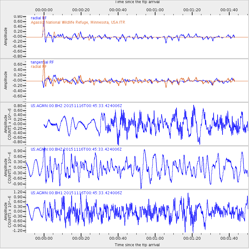
AGMN Agassiz National Wildlife Refuge, Minnesota, USA - Earthquake Result Viewer
*The percent match for this event was below the threshold and hence no stack was calculated.
| Earthquake location: |
North Of Honduras |
| Earthquake latitude/longitude: |
17.8/-81.8 |
| Earthquake time(UTC): |
2015/11/16 (320) 00:39:33 GMT |
| Earthquake Depth: |
9.1 km |
| Earthquake Magnitude: |
5.8 MWP |
| Earthquake Catalog/Contributor: |
NEIC PDE/NEIC COMCAT |
|
| Network: |
US United States National Seismic Network |
| Station: |
AGMN Agassiz National Wildlife Refuge, Minnesota, USA |
| Lat/Lon: |
48.30 N/95.86 W |
| Elevation: |
351 m |
|
| Distance: |
32.5 deg |
| Az: |
342.452 deg |
| Baz: |
154.528 deg |
| Ray Param: |
$rayparam |
*The percent match for this event was below the threshold and hence was not used in the summary stack. |
|
| Radial Match: |
61.514732 % |
| Radial Bump: |
355 |
| Transverse Match: |
55.650932 % |
| Transverse Bump: |
400 |
| SOD ConfigId: |
1259291 |
| Insert Time: |
2015-11-30 01:38:14.925 +0000 |
| GWidth: |
2.5 |
| Max Bumps: |
400 |
| Tol: |
0.001 |
|
Signal To Noise
| Channel | StoN | STA | LTA |
| US:AGMN:00:BHZ:20151116T00:45:33.424006Z | 2.012802 | 5.376146E-7 | 2.670976E-7 |
| US:AGMN:00:BH1:20151116T00:45:33.424006Z | 1.8149109 | 3.7497492E-7 | 2.0660788E-7 |
| US:AGMN:00:BH2:20151116T00:45:33.424006Z | 1.8122615 | 3.264588E-7 | 1.8013891E-7 |
| Arrivals |
| Ps | |
| PpPs | |
| PsPs/PpSs | |


