You are here: Home > Network List > US - United States National Seismic Network Stations List
> Station ELK Elko, Nevada, USA > Earthquake Result Viewer
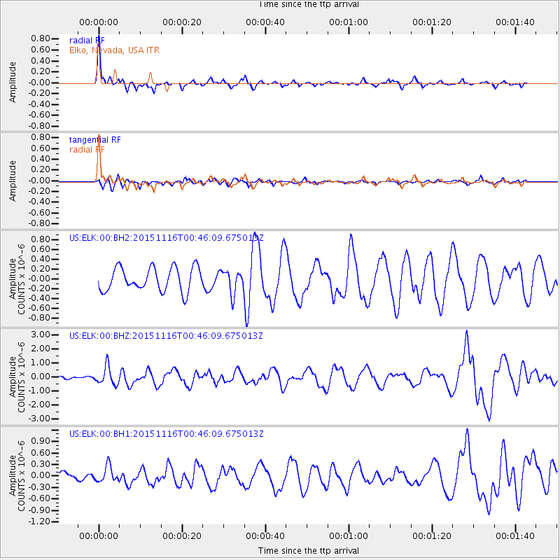
ELK Elko, Nevada, USA - Earthquake Result Viewer
*The percent match for this event was below the threshold and hence no stack was calculated.
| Earthquake location: |
North Of Honduras |
| Earthquake latitude/longitude: |
17.8/-81.8 |
| Earthquake time(UTC): |
2015/11/16 (320) 00:39:33 GMT |
| Earthquake Depth: |
9.1 km |
| Earthquake Magnitude: |
5.8 MWP |
| Earthquake Catalog/Contributor: |
NEIC PDE/NEIC COMCAT |
|
| Network: |
US United States National Seismic Network |
| Station: |
ELK Elko, Nevada, USA |
| Lat/Lon: |
40.74 N/115.24 W |
| Elevation: |
2210 m |
|
| Distance: |
36.7 deg |
| Az: |
315.532 deg |
| Baz: |
118.577 deg |
| Ray Param: |
$rayparam |
*The percent match for this event was below the threshold and hence was not used in the summary stack. |
|
| Radial Match: |
79.276184 % |
| Radial Bump: |
389 |
| Transverse Match: |
48.661648 % |
| Transverse Bump: |
400 |
| SOD ConfigId: |
1259291 |
| Insert Time: |
2015-11-30 01:38:40.797 +0000 |
| GWidth: |
2.5 |
| Max Bumps: |
400 |
| Tol: |
0.001 |
|
Signal To Noise
| Channel | StoN | STA | LTA |
| US:ELK:00:BHZ:20151116T00:46:09.675013Z | 3.4203253 | 6.4306545E-7 | 1.8801295E-7 |
| US:ELK:00:BH1:20151116T00:46:09.675013Z | 1.1565496 | 2.164702E-7 | 1.8716896E-7 |
| US:ELK:00:BH2:20151116T00:46:09.675013Z | 0.9962923 | 2.3780089E-7 | 2.3868586E-7 |
| Arrivals |
| Ps | |
| PpPs | |
| PsPs/PpSs | |


