You are here: Home > Network List > KZ - Kazakhstan Network Stations List
> Station MKAR Makanchi array,MK31, Kazakhstan > Earthquake Result Viewer
MKAR Makanchi array,MK31, Kazakhstan - Earthquake Result Viewer
| Earthquake location: |
Solomon Islands |
| Earthquake latitude/longitude: |
-7.4/155.7 |
| Earthquake time(UTC): |
2017/03/04 (063) 02:58:24 GMT |
| Earthquake Depth: |
54 km |
| Earthquake Magnitude: |
5.9 Mww |
| Earthquake Catalog/Contributor: |
NEIC PDE/us |
|
| Network: |
KZ Kazakhstan Network |
| Station: |
MKAR Makanchi array,MK31, Kazakhstan |
| Lat/Lon: |
46.79 N/82.29 E |
| Elevation: |
615 m |
|
| Distance: |
84.1 deg |
| Az: |
318.552 deg |
| Baz: |
107.134 deg |
| Ray Param: |
0.04560168 |
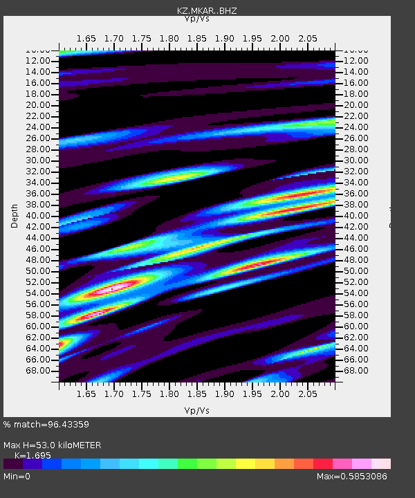
| Estimated Moho Depth: |
53.0 km |
| Estimated Crust Vp/Vs: |
1.70 |
| Assumed Crust Vp: |
6.688 km/s |
| Estimated Crust Vs: |
3.946 km/s |
| Estimated Crust Poisson's Ratio: |
0.23 |
|
| Radial Match: |
96.43359 % |
| Radial Bump: |
400 |
| Transverse Match: |
95.06759 % |
| Transverse Bump: |
400 |
| SOD ConfigId: |
11737051 |
| Insert Time: |
2019-04-26 21:14:51.827 +0000 |
| GWidth: |
2.5 |
| Max Bumps: |
400 |
| Tol: |
0.001 |
|

Signal To Noise
| Channel | StoN | STA | LTA |
| KZ:MKAR: :BHZ:20170304T03:10:18.876025Z | 63.990124 | 7.8886405E-6 | 1.2327902E-7 |
| KZ:MKAR: :BHN:20170304T03:10:18.876025Z | 22.711424 | 1.1949434E-6 | 5.26142E-8 |
| KZ:MKAR: :BHE:20170304T03:10:18.876025Z | 16.265623 | 1.7064563E-6 | 1.0491182E-7 |
| Arrivals |
| Ps | 5.7 SECOND |
| PpPs | 21 SECOND |
| PsPs/PpSs | 26 SECOND |


