You are here: Home > Network List > TA - USArray Transportable Network (new EarthScope stations) Stations List
> Station A21K Barrow, AK, USA > Earthquake Result Viewer
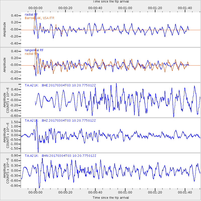
A21K Barrow, AK, USA - Earthquake Result Viewer
*The percent match for this event was below the threshold and hence no stack was calculated.
| Earthquake location: |
Solomon Islands |
| Earthquake latitude/longitude: |
-7.4/155.7 |
| Earthquake time(UTC): |
2017/03/04 (063) 02:58:24 GMT |
| Earthquake Depth: |
54 km |
| Earthquake Magnitude: |
5.9 Mww |
| Earthquake Catalog/Contributor: |
NEIC PDE/us |
|
| Network: |
TA USArray Transportable Network (new EarthScope stations) |
| Station: |
A21K Barrow, AK, USA |
| Lat/Lon: |
71.32 N/156.62 W |
| Elevation: |
577 m |
|
| Distance: |
84.6 deg |
| Az: |
13.845 deg |
| Baz: |
227.45 deg |
| Ray Param: |
$rayparam |
*The percent match for this event was below the threshold and hence was not used in the summary stack. |
|
| Radial Match: |
61.766953 % |
| Radial Bump: |
367 |
| Transverse Match: |
65.44552 % |
| Transverse Bump: |
400 |
| SOD ConfigId: |
11737051 |
| Insert Time: |
2019-04-26 21:15:52.556 +0000 |
| GWidth: |
2.5 |
| Max Bumps: |
400 |
| Tol: |
0.001 |
|
Signal To Noise
| Channel | StoN | STA | LTA |
| TA:A21K: :BHZ:20170304T03:10:20.775012Z | 6.41409 | 8.4858027E-7 | 1.322994E-7 |
| TA:A21K: :BHN:20170304T03:10:20.775012Z | 1.2627227 | 4.7485224E-7 | 3.7605423E-7 |
| TA:A21K: :BHE:20170304T03:10:20.775012Z | 1.2596576 | 2.3045325E-7 | 1.8294912E-7 |
| Arrivals |
| Ps | |
| PpPs | |
| PsPs/PpSs | |


