You are here: Home > Network List > TA - USArray Transportable Network (new EarthScope stations) Stations List
> Station D25K Kavik River, AK, USA > Earthquake Result Viewer
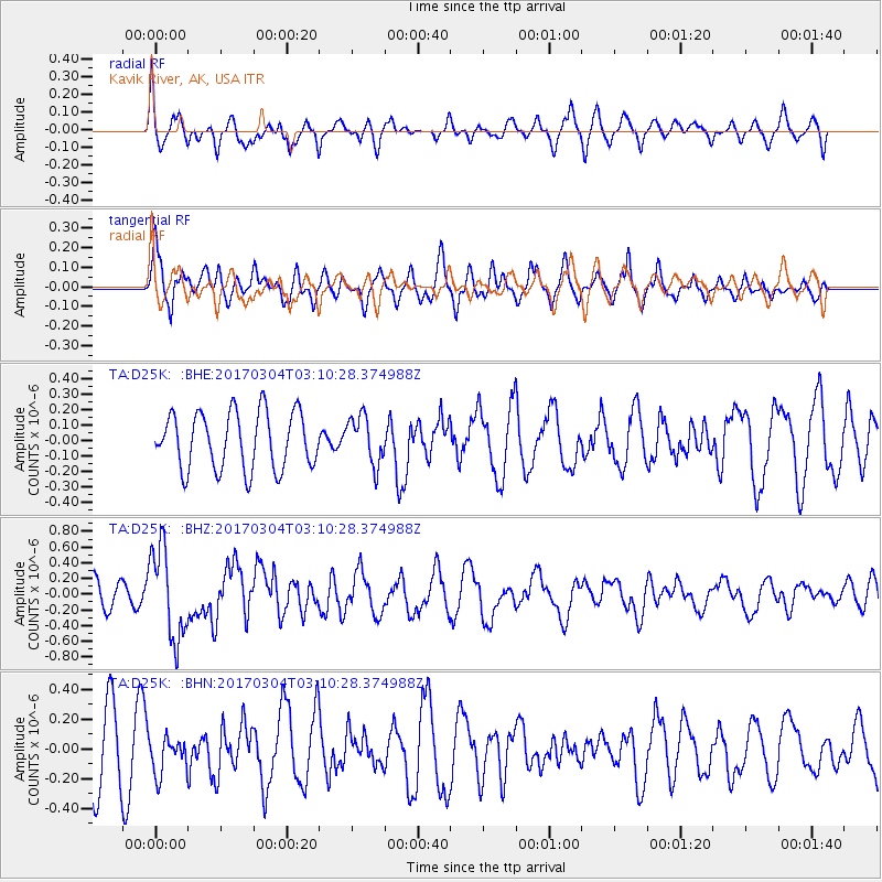
D25K Kavik River, AK, USA - Earthquake Result Viewer
*The percent match for this event was below the threshold and hence no stack was calculated.
| Earthquake location: |
Solomon Islands |
| Earthquake latitude/longitude: |
-7.4/155.7 |
| Earthquake time(UTC): |
2017/03/04 (063) 02:58:24 GMT |
| Earthquake Depth: |
54 km |
| Earthquake Magnitude: |
5.9 Mww |
| Earthquake Catalog/Contributor: |
NEIC PDE/us |
|
| Network: |
TA USArray Transportable Network (new EarthScope stations) |
| Station: |
D25K Kavik River, AK, USA |
| Lat/Lon: |
69.32 N/146.38 W |
| Elevation: |
770 m |
|
| Distance: |
86.1 deg |
| Az: |
17.558 deg |
| Baz: |
237.394 deg |
| Ray Param: |
$rayparam |
*The percent match for this event was below the threshold and hence was not used in the summary stack. |
|
| Radial Match: |
42.054398 % |
| Radial Bump: |
400 |
| Transverse Match: |
50.644646 % |
| Transverse Bump: |
400 |
| SOD ConfigId: |
11737051 |
| Insert Time: |
2019-04-26 21:15:57.389 +0000 |
| GWidth: |
2.5 |
| Max Bumps: |
400 |
| Tol: |
0.001 |
|
Signal To Noise
| Channel | StoN | STA | LTA |
| TA:D25K: :BHZ:20170304T03:10:28.374988Z | 3.47189 | 5.7696326E-7 | 1.6618132E-7 |
| TA:D25K: :BHN:20170304T03:10:28.374988Z | 0.60462445 | 1.2750961E-7 | 2.1089058E-7 |
| TA:D25K: :BHE:20170304T03:10:28.374988Z | 0.84044963 | 1.5436164E-7 | 1.8366555E-7 |
| Arrivals |
| Ps | |
| PpPs | |
| PsPs/PpSs | |


