You are here: Home > Network List > TA - USArray Transportable Network (new EarthScope stations) Stations List
> Station R11A Troy Canyon, Currant, NV, USA > Earthquake Result Viewer
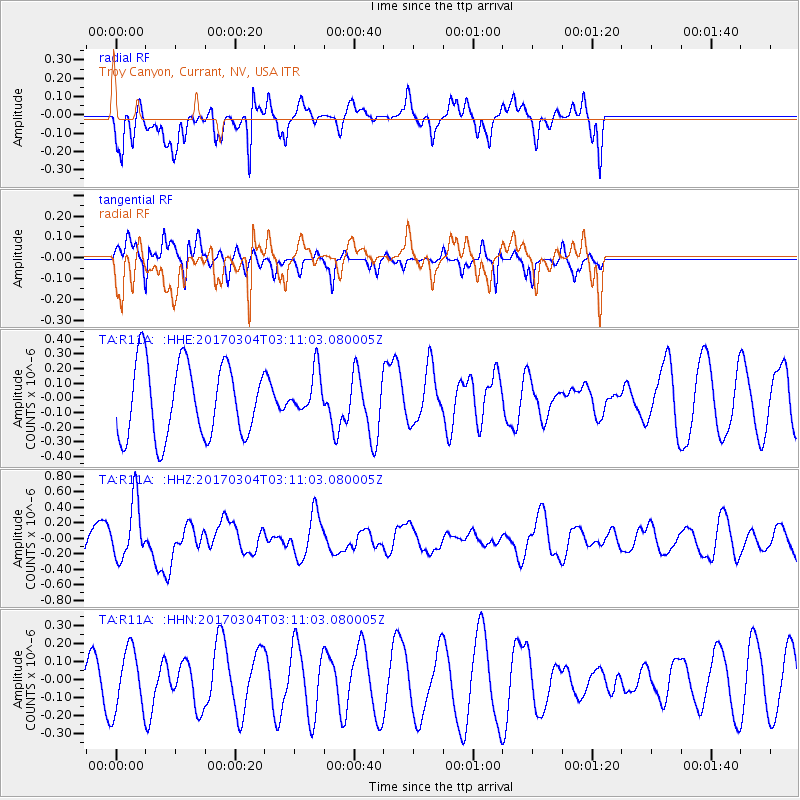
R11A Troy Canyon, Currant, NV, USA - Earthquake Result Viewer
*The percent match for this event was below the threshold and hence no stack was calculated.
| Earthquake location: |
Solomon Islands |
| Earthquake latitude/longitude: |
-7.4/155.7 |
| Earthquake time(UTC): |
2017/03/04 (063) 02:58:24 GMT |
| Earthquake Depth: |
54 km |
| Earthquake Magnitude: |
5.9 Mww |
| Earthquake Catalog/Contributor: |
NEIC PDE/us |
|
| Network: |
TA USArray Transportable Network (new EarthScope stations) |
| Station: |
R11A Troy Canyon, Currant, NV, USA |
| Lat/Lon: |
38.35 N/115.59 W |
| Elevation: |
1756 m |
|
| Distance: |
93.5 deg |
| Az: |
51.956 deg |
| Baz: |
263.456 deg |
| Ray Param: |
$rayparam |
*The percent match for this event was below the threshold and hence was not used in the summary stack. |
|
| Radial Match: |
45.838882 % |
| Radial Bump: |
281 |
| Transverse Match: |
39.03951 % |
| Transverse Bump: |
255 |
| SOD ConfigId: |
11737051 |
| Insert Time: |
2019-04-26 21:16:29.072 +0000 |
| GWidth: |
2.5 |
| Max Bumps: |
400 |
| Tol: |
0.001 |
|
Signal To Noise
| Channel | StoN | STA | LTA |
| TA:R11A: :HHZ:20170304T03:11:03.080005Z | 2.155468 | 3.7360456E-7 | 1.7332876E-7 |
| TA:R11A: :HHN:20170304T03:11:03.080005Z | 1.1218373 | 1.732834E-7 | 1.5446392E-7 |
| TA:R11A: :HHE:20170304T03:11:03.080005Z | 0.5769246 | 1.4470254E-7 | 2.5081707E-7 |
| Arrivals |
| Ps | |
| PpPs | |
| PsPs/PpSs | |


