You are here: Home > Network List > WY - Yellowstone Wyoming Seismic Network Stations List
> Station YHH Holmes Hill, YNP, WY, USA > Earthquake Result Viewer
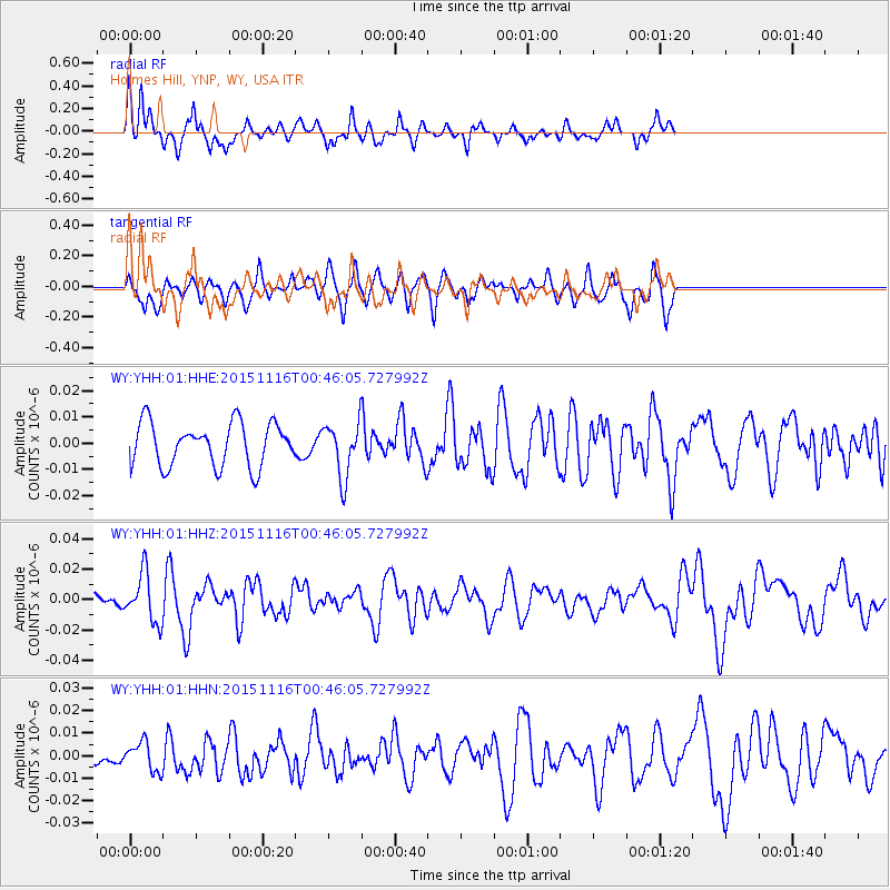
YHH Holmes Hill, YNP, WY, USA - Earthquake Result Viewer
*The percent match for this event was below the threshold and hence no stack was calculated.
| Earthquake location: |
North Of Honduras |
| Earthquake latitude/longitude: |
17.8/-81.8 |
| Earthquake time(UTC): |
2015/11/16 (320) 00:39:33 GMT |
| Earthquake Depth: |
9.1 km |
| Earthquake Magnitude: |
5.8 MWP |
| Earthquake Catalog/Contributor: |
NEIC PDE/NEIC COMCAT |
|
| Network: |
WY Yellowstone Wyoming Seismic Network |
| Station: |
YHH Holmes Hill, YNP, WY, USA |
| Lat/Lon: |
44.79 N/110.85 W |
| Elevation: |
2717 m |
|
| Distance: |
36.2 deg |
| Az: |
324.214 deg |
| Baz: |
128.538 deg |
| Ray Param: |
$rayparam |
*The percent match for this event was below the threshold and hence was not used in the summary stack. |
|
| Radial Match: |
69.09882 % |
| Radial Bump: |
249 |
| Transverse Match: |
58.88842 % |
| Transverse Bump: |
400 |
| SOD ConfigId: |
1259291 |
| Insert Time: |
2015-11-30 01:41:11.623 +0000 |
| GWidth: |
2.5 |
| Max Bumps: |
400 |
| Tol: |
0.001 |
|
Signal To Noise
| Channel | StoN | STA | LTA |
| WY:YHH:01:HHZ:20151116T00:46:05.727992Z | 2.6114833 | 1.5843858E-8 | 6.0669962E-9 |
| WY:YHH:01:HHN:20151116T00:46:05.727992Z | 1.3858742 | 6.316025E-9 | 4.5574304E-9 |
| WY:YHH:01:HHE:20151116T00:46:05.727992Z | 1.2439219 | 1.0262139E-8 | 8.249826E-9 |
| Arrivals |
| Ps | |
| PpPs | |
| PsPs/PpSs | |


