You are here: Home > Network List > AZ - ANZA Regional Network Stations List
> Station LVA2 AZ.LVA2 > Earthquake Result Viewer
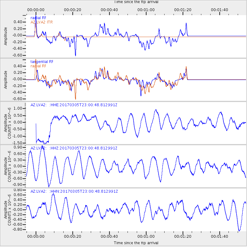
LVA2 AZ.LVA2 - Earthquake Result Viewer
*The percent match for this event was below the threshold and hence no stack was calculated.
| Earthquake location: |
New Britain Region, P.N.G. |
| Earthquake latitude/longitude: |
-6.0/149.4 |
| Earthquake time(UTC): |
2017/03/05 (064) 22:47:53 GMT |
| Earthquake Depth: |
31 km |
| Earthquake Magnitude: |
6.3 mww |
| Earthquake Catalog/Contributor: |
NEIC PDE/us |
|
| Network: |
AZ ANZA Regional Network |
| Station: |
LVA2 AZ.LVA2 |
| Lat/Lon: |
33.35 N/116.56 W |
| Elevation: |
1435 m |
|
| Distance: |
96.7 deg |
| Az: |
57.199 deg |
| Baz: |
267.223 deg |
| Ray Param: |
$rayparam |
*The percent match for this event was below the threshold and hence was not used in the summary stack. |
|
| Radial Match: |
47.556023 % |
| Radial Bump: |
400 |
| Transverse Match: |
53.87991 % |
| Transverse Bump: |
400 |
| SOD ConfigId: |
11737051 |
| Insert Time: |
2019-04-26 21:30:36.077 +0000 |
| GWidth: |
2.5 |
| Max Bumps: |
400 |
| Tol: |
0.001 |
|
Signal To Noise
| Channel | StoN | STA | LTA |
| AZ:LVA2: :HHZ:20170305T23:00:48.812991Z | 1.7819108 | 6.732046E-7 | 3.777993E-7 |
| AZ:LVA2: :HHN:20170305T23:00:48.812991Z | 0.42951304 | 1.9645405E-7 | 4.5738787E-7 |
| AZ:LVA2: :HHE:20170305T23:00:48.812991Z | 0.65922374 | 5.0775867E-7 | 7.702373E-7 |
| Arrivals |
| Ps | |
| PpPs | |
| PsPs/PpSs | |


