You are here: Home > Network List > CN - Canadian National Seismograph Network Stations List
> Station INK INUVIK, NT > Earthquake Result Viewer
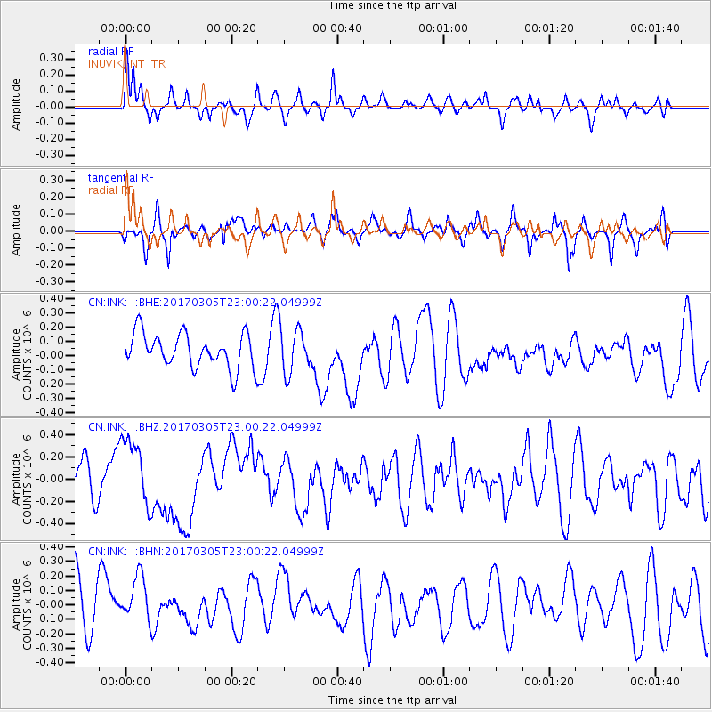
INK INUVIK, NT - Earthquake Result Viewer
*The percent match for this event was below the threshold and hence no stack was calculated.
| Earthquake location: |
New Britain Region, P.N.G. |
| Earthquake latitude/longitude: |
-6.0/149.4 |
| Earthquake time(UTC): |
2017/03/05 (064) 22:47:53 GMT |
| Earthquake Depth: |
31 km |
| Earthquake Magnitude: |
6.3 mww |
| Earthquake Catalog/Contributor: |
NEIC PDE/us |
|
| Network: |
CN Canadian National Seismograph Network |
| Station: |
INK INUVIK, NT |
| Lat/Lon: |
68.31 N/133.53 W |
| Elevation: |
44 m |
|
| Distance: |
90.8 deg |
| Az: |
21.252 deg |
| Baz: |
255.853 deg |
| Ray Param: |
$rayparam |
*The percent match for this event was below the threshold and hence was not used in the summary stack. |
|
| Radial Match: |
54.30634 % |
| Radial Bump: |
400 |
| Transverse Match: |
56.501965 % |
| Transverse Bump: |
400 |
| SOD ConfigId: |
11737051 |
| Insert Time: |
2019-04-26 21:31:42.623 +0000 |
| GWidth: |
2.5 |
| Max Bumps: |
400 |
| Tol: |
0.001 |
|
Signal To Noise
| Channel | StoN | STA | LTA |
| CN:INK: :BHZ:20170305T23:00:22.04999Z | 1.7339215 | 3.1692414E-7 | 1.8277883E-7 |
| CN:INK: :BHN:20170305T23:00:22.04999Z | 1.1836506 | 1.8038632E-7 | 1.5239829E-7 |
| CN:INK: :BHE:20170305T23:00:22.04999Z | 1.2723781 | 1.5368177E-7 | 1.207831E-7 |
| Arrivals |
| Ps | |
| PpPs | |
| PsPs/PpSs | |


