You are here: Home > Network List > TA - USArray Transportable Network (new EarthScope stations) Stations List
> Station A21K Barrow, AK, USA > Earthquake Result Viewer
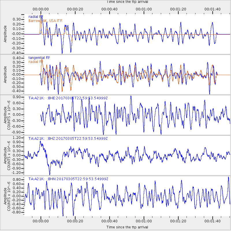
A21K Barrow, AK, USA - Earthquake Result Viewer
*The percent match for this event was below the threshold and hence no stack was calculated.
| Earthquake location: |
New Britain Region, P.N.G. |
| Earthquake latitude/longitude: |
-6.0/149.4 |
| Earthquake time(UTC): |
2017/03/05 (064) 22:47:53 GMT |
| Earthquake Depth: |
31 km |
| Earthquake Magnitude: |
6.3 mww |
| Earthquake Catalog/Contributor: |
NEIC PDE/us |
|
| Network: |
TA USArray Transportable Network (new EarthScope stations) |
| Station: |
A21K Barrow, AK, USA |
| Lat/Lon: |
71.32 N/156.62 W |
| Elevation: |
577 m |
|
| Distance: |
84.8 deg |
| Az: |
15.177 deg |
| Baz: |
233.923 deg |
| Ray Param: |
$rayparam |
*The percent match for this event was below the threshold and hence was not used in the summary stack. |
|
| Radial Match: |
58.57392 % |
| Radial Bump: |
400 |
| Transverse Match: |
43.28619 % |
| Transverse Bump: |
400 |
| SOD ConfigId: |
11737051 |
| Insert Time: |
2019-04-26 21:33:32.789 +0000 |
| GWidth: |
2.5 |
| Max Bumps: |
400 |
| Tol: |
0.001 |
|
Signal To Noise
| Channel | StoN | STA | LTA |
| TA:A21K: :BHZ:20170305T22:59:53.54999Z | 4.483298 | 6.130277E-7 | 1.3673588E-7 |
| TA:A21K: :BHN:20170305T22:59:53.54999Z | 1.3089198 | 3.2554058E-7 | 2.4870934E-7 |
| TA:A21K: :BHE:20170305T22:59:53.54999Z | 0.9593477 | 3.0747475E-7 | 3.2050397E-7 |
| Arrivals |
| Ps | |
| PpPs | |
| PsPs/PpSs | |


