You are here: Home > Network List > TA - USArray Transportable Network (new EarthScope stations) Stations List
> Station D25K Kavik River, AK, USA > Earthquake Result Viewer
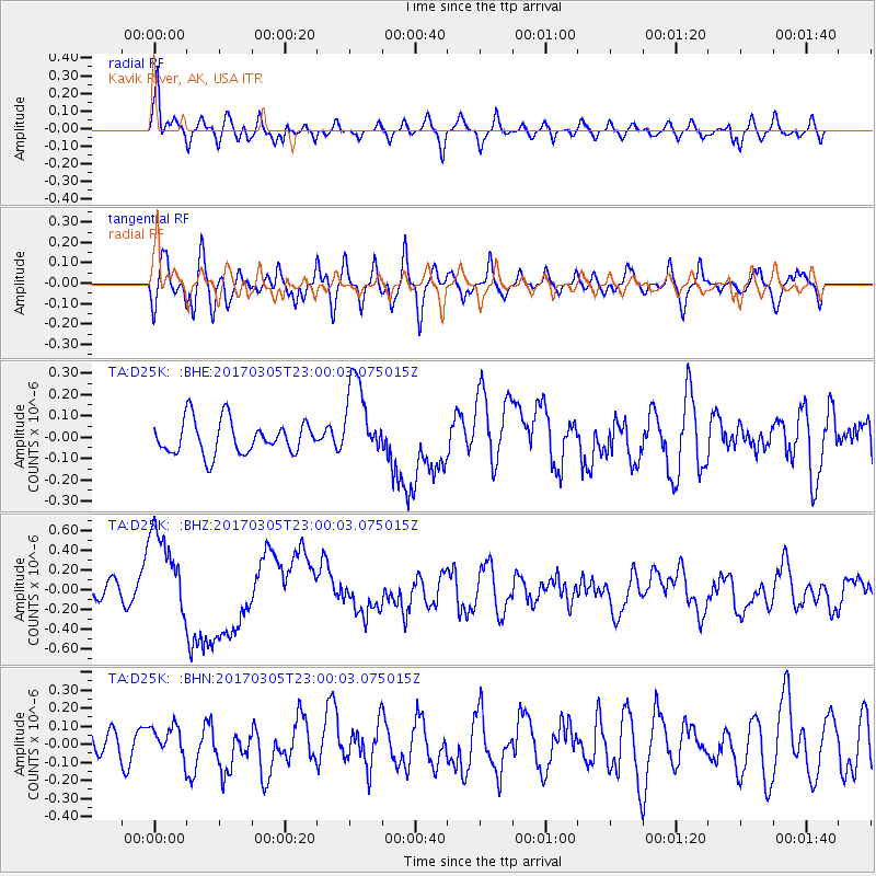
D25K Kavik River, AK, USA - Earthquake Result Viewer
*The percent match for this event was below the threshold and hence no stack was calculated.
| Earthquake location: |
New Britain Region, P.N.G. |
| Earthquake latitude/longitude: |
-6.0/149.4 |
| Earthquake time(UTC): |
2017/03/05 (064) 22:47:53 GMT |
| Earthquake Depth: |
31 km |
| Earthquake Magnitude: |
6.3 mww |
| Earthquake Catalog/Contributor: |
NEIC PDE/us |
|
| Network: |
TA USArray Transportable Network (new EarthScope stations) |
| Station: |
D25K Kavik River, AK, USA |
| Lat/Lon: |
69.32 N/146.38 W |
| Elevation: |
770 m |
|
| Distance: |
86.8 deg |
| Az: |
18.693 deg |
| Baz: |
243.821 deg |
| Ray Param: |
$rayparam |
*The percent match for this event was below the threshold and hence was not used in the summary stack. |
|
| Radial Match: |
74.94744 % |
| Radial Bump: |
400 |
| Transverse Match: |
54.033405 % |
| Transverse Bump: |
400 |
| SOD ConfigId: |
11737051 |
| Insert Time: |
2019-04-26 21:33:37.232 +0000 |
| GWidth: |
2.5 |
| Max Bumps: |
400 |
| Tol: |
0.001 |
|
Signal To Noise
| Channel | StoN | STA | LTA |
| TA:D25K: :BHZ:20170305T23:00:03.075015Z | 5.323328 | 4.5279754E-7 | 8.5059106E-8 |
| TA:D25K: :BHN:20170305T23:00:03.075015Z | 0.6346483 | 8.639982E-8 | 1.361381E-7 |
| TA:D25K: :BHE:20170305T23:00:03.075015Z | 2.4307861 | 1.885804E-7 | 7.758E-8 |
| Arrivals |
| Ps | |
| PpPs | |
| PsPs/PpSs | |


