You are here: Home > Network List > TA - USArray Transportable Network (new EarthScope stations) Stations List
> Station G21K Allakaket, AK, USA > Earthquake Result Viewer
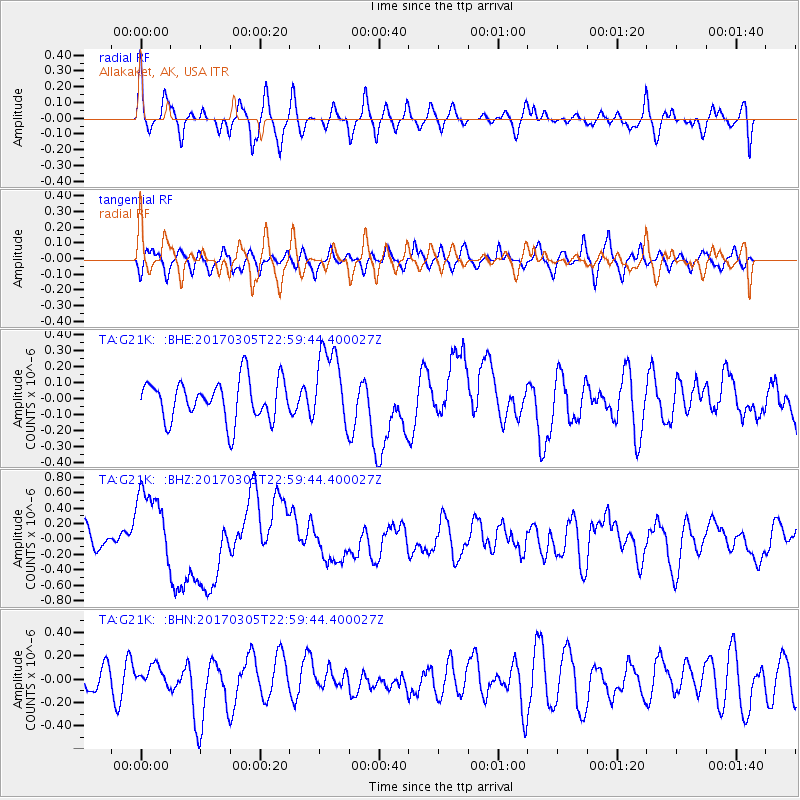
G21K Allakaket, AK, USA - Earthquake Result Viewer
*The percent match for this event was below the threshold and hence no stack was calculated.
| Earthquake location: |
New Britain Region, P.N.G. |
| Earthquake latitude/longitude: |
-6.0/149.4 |
| Earthquake time(UTC): |
2017/03/05 (064) 22:47:53 GMT |
| Earthquake Depth: |
31 km |
| Earthquake Magnitude: |
6.3 mww |
| Earthquake Catalog/Contributor: |
NEIC PDE/us |
|
| Network: |
TA USArray Transportable Network (new EarthScope stations) |
| Station: |
G21K Allakaket, AK, USA |
| Lat/Lon: |
66.52 N/153.51 W |
| Elevation: |
446 m |
|
| Distance: |
83.0 deg |
| Az: |
19.824 deg |
| Baz: |
237.317 deg |
| Ray Param: |
$rayparam |
*The percent match for this event was below the threshold and hence was not used in the summary stack. |
|
| Radial Match: |
71.24889 % |
| Radial Bump: |
400 |
| Transverse Match: |
58.17815 % |
| Transverse Bump: |
400 |
| SOD ConfigId: |
11737051 |
| Insert Time: |
2019-04-26 21:33:43.523 +0000 |
| GWidth: |
2.5 |
| Max Bumps: |
400 |
| Tol: |
0.001 |
|
Signal To Noise
| Channel | StoN | STA | LTA |
| TA:G21K: :BHZ:20170305T22:59:44.400027Z | 4.3930364 | 5.1421034E-7 | 1.1705123E-7 |
| TA:G21K: :BHN:20170305T22:59:44.400027Z | 0.54523134 | 8.8663064E-8 | 1.6261549E-7 |
| TA:G21K: :BHE:20170305T22:59:44.400027Z | 1.9667438 | 2.4377957E-7 | 1.2395085E-7 |
| Arrivals |
| Ps | |
| PpPs | |
| PsPs/PpSs | |


