You are here: Home > Network List > CB - China National Seismic Network Stations List
> Station HHC Huhehaote,Neimeng Province > Earthquake Result Viewer
HHC Huhehaote,Neimeng Province - Earthquake Result Viewer
| Earthquake location: |
Southwest Of Sumatra, Indonesia |
| Earthquake latitude/longitude: |
-6.3/102.1 |
| Earthquake time(UTC): |
2017/03/07 (066) 15:45:39 GMT |
| Earthquake Depth: |
10 km |
| Earthquake Magnitude: |
5.3 Mww |
| Earthquake Catalog/Contributor: |
NEIC PDE/us |
|
| Network: |
CB China National Seismic Network |
| Station: |
HHC Huhehaote,Neimeng Province |
| Lat/Lon: |
40.85 N/111.56 E |
| Elevation: |
1169 m |
|
| Distance: |
47.7 deg |
| Az: |
9.662 deg |
| Baz: |
192.705 deg |
| Ray Param: |
0.06983433 |
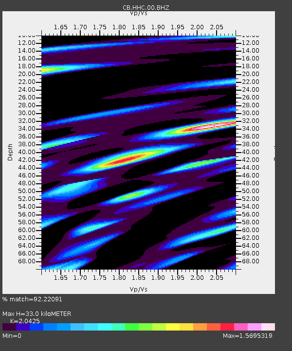
| Estimated Moho Depth: |
33.0 km |
| Estimated Crust Vp/Vs: |
2.04 |
| Assumed Crust Vp: |
6.384 km/s |
| Estimated Crust Vs: |
3.126 km/s |
| Estimated Crust Poisson's Ratio: |
0.34 |
|
| Radial Match: |
92.22091 % |
| Radial Bump: |
400 |
| Transverse Match: |
81.583046 % |
| Transverse Bump: |
400 |
| SOD ConfigId: |
11737051 |
| Insert Time: |
2019-04-26 21:37:35.421 +0000 |
| GWidth: |
2.5 |
| Max Bumps: |
400 |
| Tol: |
0.001 |
|

Signal To Noise
| Channel | StoN | STA | LTA |
| CB:HHC:00:BHZ:20170307T15:53:45.039999Z | 5.1188087 | 7.146943E-7 | 1.396212E-7 |
| CB:HHC:00:BHN:20170307T15:53:45.039999Z | 3.0429819 | 4.294545E-7 | 1.4112949E-7 |
| CB:HHC:00:BHE:20170307T15:53:45.039999Z | 1.3947898 | 1.8292657E-7 | 1.3114992E-7 |
| Arrivals |
| Ps | 5.7 SECOND |
| PpPs | 15 SECOND |
| PsPs/PpSs | 21 SECOND |


