You are here: Home > Network List > TJ - Tajikistan National Seismic Network Stations List
> Station MANEM Manem, Tajikistan > Earthquake Result Viewer
MANEM Manem, Tajikistan - Earthquake Result Viewer
| Earthquake location: |
Southwest Of Sumatra, Indonesia |
| Earthquake latitude/longitude: |
-6.3/102.1 |
| Earthquake time(UTC): |
2017/03/07 (066) 15:45:39 GMT |
| Earthquake Depth: |
10 km |
| Earthquake Magnitude: |
5.3 Mww |
| Earthquake Catalog/Contributor: |
NEIC PDE/us |
|
| Network: |
TJ Tajikistan National Seismic Network |
| Station: |
MANEM Manem, Tajikistan |
| Lat/Lon: |
37.53 N/71.66 E |
| Elevation: |
2312 m |
|
| Distance: |
52.0 deg |
| Az: |
329.227 deg |
| Baz: |
140.225 deg |
| Ray Param: |
0.06702119 |
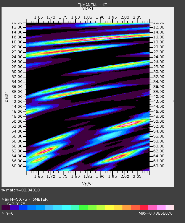
| Estimated Moho Depth: |
50.75 km |
| Estimated Crust Vp/Vs: |
2.02 |
| Assumed Crust Vp: |
6.306 km/s |
| Estimated Crust Vs: |
3.126 km/s |
| Estimated Crust Poisson's Ratio: |
0.34 |
|
| Radial Match: |
88.34818 % |
| Radial Bump: |
335 |
| Transverse Match: |
81.815796 % |
| Transverse Bump: |
400 |
| SOD ConfigId: |
11737051 |
| Insert Time: |
2019-04-26 21:39:16.813 +0000 |
| GWidth: |
2.5 |
| Max Bumps: |
400 |
| Tol: |
0.001 |
|

Signal To Noise
| Channel | StoN | STA | LTA |
| TJ:MANEM: :HHZ:20170307T15:54:18.28002Z | 4.851175 | 7.248194E-7 | 1.4941111E-7 |
| TJ:MANEM: :HHN:20170307T15:54:18.28002Z | 3.4058273 | 2.2097129E-7 | 6.488035E-8 |
| TJ:MANEM: :HHE:20170307T15:54:18.28002Z | 4.1737247 | 2.5269662E-7 | 6.054463E-8 |
| Arrivals |
| Ps | 8.6 SECOND |
| PpPs | 23 SECOND |
| PsPs/PpSs | 32 SECOND |


