You are here: Home > Network List > AV - Alaska Volcano Observatory Stations List
> Station SPCR Ckakachatna River, Mount Spurr, Alaska > Earthquake Result Viewer
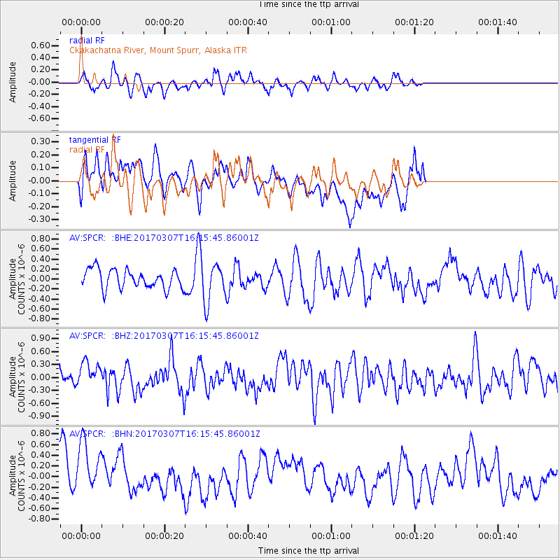
SPCR Ckakachatna River, Mount Spurr, Alaska - Earthquake Result Viewer
*The percent match for this event was below the threshold and hence no stack was calculated.
| Earthquake location: |
Hokkaido, Japan Region |
| Earthquake latitude/longitude: |
41.5/141.9 |
| Earthquake time(UTC): |
2017/03/07 (066) 16:08:18 GMT |
| Earthquake Depth: |
50 km |
| Earthquake Magnitude: |
5.7 Mww |
| Earthquake Catalog/Contributor: |
NEIC PDE/us |
|
| Network: |
AV Alaska Volcano Observatory |
| Station: |
SPCR Ckakachatna River, Mount Spurr, Alaska |
| Lat/Lon: |
61.20 N/152.21 W |
| Elevation: |
984 m |
|
| Distance: |
43.4 deg |
| Az: |
40.032 deg |
| Baz: |
274.311 deg |
| Ray Param: |
$rayparam |
*The percent match for this event was below the threshold and hence was not used in the summary stack. |
|
| Radial Match: |
62.71399 % |
| Radial Bump: |
387 |
| Transverse Match: |
47.617676 % |
| Transverse Bump: |
400 |
| SOD ConfigId: |
11737051 |
| Insert Time: |
2019-04-26 21:41:24.384 +0000 |
| GWidth: |
2.5 |
| Max Bumps: |
400 |
| Tol: |
0.001 |
|
Signal To Noise
| Channel | StoN | STA | LTA |
| AV:SPCR: :BHZ:20170307T16:15:45.86001Z | 1.0855379 | 3.0184037E-7 | 2.7805604E-7 |
| AV:SPCR: :BHN:20170307T16:15:45.86001Z | 2.1908572 | 5.5326376E-7 | 2.52533E-7 |
| AV:SPCR: :BHE:20170307T16:15:45.86001Z | 2.0934672 | 3.9658192E-7 | 1.8943784E-7 |
| Arrivals |
| Ps | |
| PpPs | |
| PsPs/PpSs | |


