You are here: Home > Network List > TA - USArray Transportable Network (new EarthScope stations) Stations List
> Station A21K Barrow, AK, USA > Earthquake Result Viewer
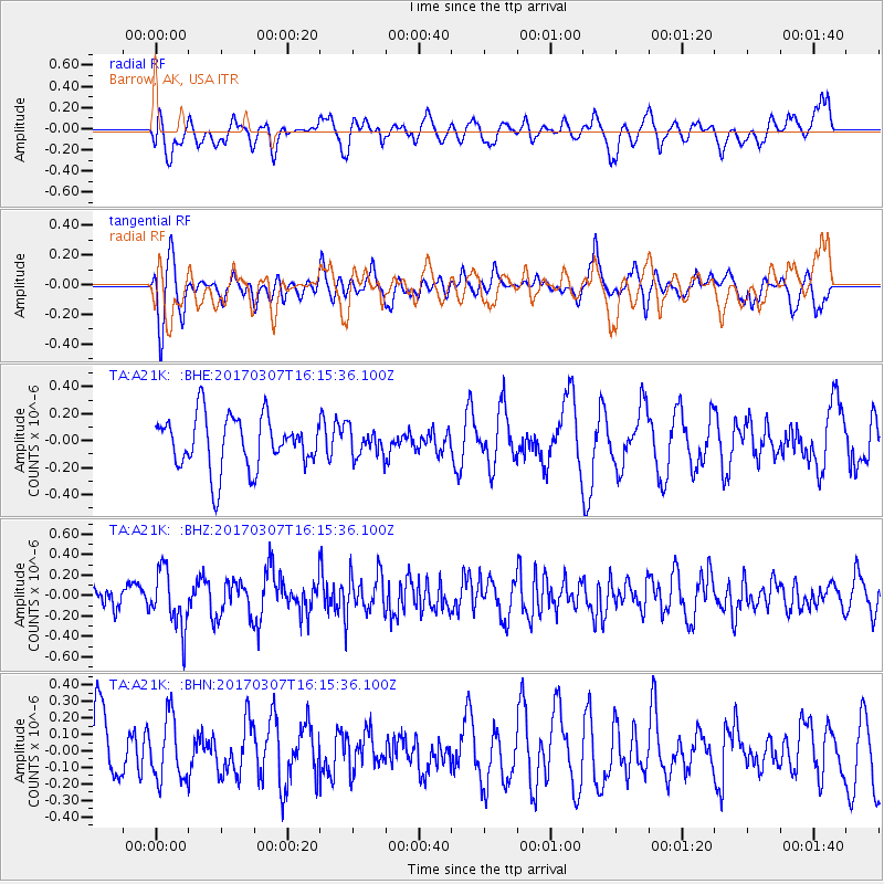
A21K Barrow, AK, USA - Earthquake Result Viewer
*The percent match for this event was below the threshold and hence no stack was calculated.
| Earthquake location: |
Hokkaido, Japan Region |
| Earthquake latitude/longitude: |
41.5/141.9 |
| Earthquake time(UTC): |
2017/03/07 (066) 16:08:18 GMT |
| Earthquake Depth: |
50 km |
| Earthquake Magnitude: |
5.7 Mww |
| Earthquake Catalog/Contributor: |
NEIC PDE/us |
|
| Network: |
TA USArray Transportable Network (new EarthScope stations) |
| Station: |
A21K Barrow, AK, USA |
| Lat/Lon: |
71.32 N/156.62 W |
| Elevation: |
577 m |
|
| Distance: |
42.2 deg |
| Az: |
24.93 deg |
| Baz: |
259.152 deg |
| Ray Param: |
$rayparam |
*The percent match for this event was below the threshold and hence was not used in the summary stack. |
|
| Radial Match: |
53.84245 % |
| Radial Bump: |
400 |
| Transverse Match: |
54.462326 % |
| Transverse Bump: |
372 |
| SOD ConfigId: |
11737051 |
| Insert Time: |
2019-04-26 21:46:48.426 +0000 |
| GWidth: |
2.5 |
| Max Bumps: |
400 |
| Tol: |
0.001 |
|
Signal To Noise
| Channel | StoN | STA | LTA |
| TA:A21K: :BHZ:20170307T16:15:36.100Z | 3.289835 | 2.775365E-7 | 8.436182E-8 |
| TA:A21K: :BHN:20170307T16:15:36.100Z | 0.69119483 | 1.9003042E-7 | 2.7493033E-7 |
| TA:A21K: :BHE:20170307T16:15:36.100Z | 0.52164584 | 1.0164256E-7 | 1.9484975E-7 |
| Arrivals |
| Ps | |
| PpPs | |
| PsPs/PpSs | |


