You are here: Home > Network List > TA - USArray Transportable Network (new EarthScope stations) Stations List
> Station I23K Minto, Yukon-Koyukuk, AK, USA > Earthquake Result Viewer
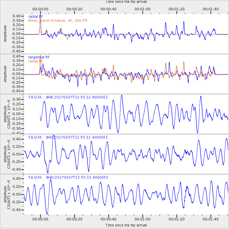
I23K Minto, Yukon-Koyukuk, AK, USA - Earthquake Result Viewer
*The percent match for this event was below the threshold and hence no stack was calculated.
| Earthquake location: |
Vanuatu Islands |
| Earthquake latitude/longitude: |
-15.0/168.2 |
| Earthquake time(UTC): |
2017/03/07 (066) 23:38:22 GMT |
| Earthquake Depth: |
8.0 km |
| Earthquake Magnitude: |
5.6 Mww |
| Earthquake Catalog/Contributor: |
NEIC PDE/us |
|
| Network: |
TA USArray Transportable Network (new EarthScope stations) |
| Station: |
I23K Minto, Yukon-Koyukuk, AK, USA |
| Lat/Lon: |
65.15 N/149.36 W |
| Elevation: |
149 m |
|
| Distance: |
86.1 deg |
| Az: |
16.621 deg |
| Baz: |
220.845 deg |
| Ray Param: |
$rayparam |
*The percent match for this event was below the threshold and hence was not used in the summary stack. |
|
| Radial Match: |
52.09281 % |
| Radial Bump: |
400 |
| Transverse Match: |
52.45841 % |
| Transverse Bump: |
370 |
| SOD ConfigId: |
11737051 |
| Insert Time: |
2019-04-26 21:53:23.470 +0000 |
| GWidth: |
2.5 |
| Max Bumps: |
400 |
| Tol: |
0.001 |
|
Signal To Noise
| Channel | StoN | STA | LTA |
| TA:I23K: :BHZ:20170307T23:50:32.400005Z | 1.903953 | 2.682821E-7 | 1.4090794E-7 |
| TA:I23K: :BHN:20170307T23:50:32.400005Z | 2.41201 | 2.7027377E-7 | 1.1205334E-7 |
| TA:I23K: :BHE:20170307T23:50:32.400005Z | 0.81463325 | 9.94773E-8 | 1.2211298E-7 |
| Arrivals |
| Ps | |
| PpPs | |
| PsPs/PpSs | |


