You are here: Home > Network List > IW - Intermountain West Stations List
> Station DLMT Dillon, Montana, USA > Earthquake Result Viewer
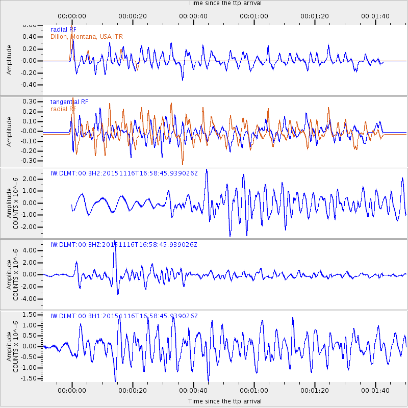
DLMT Dillon, Montana, USA - Earthquake Result Viewer
*The percent match for this event was below the threshold and hence no stack was calculated.
| Earthquake location: |
Kuril Islands |
| Earthquake latitude/longitude: |
48.3/154.3 |
| Earthquake time(UTC): |
2015/11/16 (320) 16:49:15 GMT |
| Earthquake Depth: |
42 km |
| Earthquake Magnitude: |
5.8 MWB |
| Earthquake Catalog/Contributor: |
NEIC PDE/NEIC COMCAT |
|
| Network: |
IW Intermountain West |
| Station: |
DLMT Dillon, Montana, USA |
| Lat/Lon: |
45.36 N/112.60 W |
| Elevation: |
1569 m |
|
| Distance: |
59.9 deg |
| Az: |
54.489 deg |
| Baz: |
309.555 deg |
| Ray Param: |
$rayparam |
*The percent match for this event was below the threshold and hence was not used in the summary stack. |
|
| Radial Match: |
79.32303 % |
| Radial Bump: |
322 |
| Transverse Match: |
73.07298 % |
| Transverse Bump: |
400 |
| SOD ConfigId: |
1259291 |
| Insert Time: |
2015-11-30 17:46:40.020 +0000 |
| GWidth: |
2.5 |
| Max Bumps: |
400 |
| Tol: |
0.001 |
|
Signal To Noise
| Channel | StoN | STA | LTA |
| IW:DLMT:00:BHZ:20151116T16:58:45.939026Z | 5.1395965 | 1.0110182E-6 | 1.967116E-7 |
| IW:DLMT:00:BH1:20151116T16:58:45.939026Z | 1.9625758 | 4.6208987E-7 | 2.3545073E-7 |
| IW:DLMT:00:BH2:20151116T16:58:45.939026Z | 1.2952775 | 5.575775E-7 | 4.3046953E-7 |
| Arrivals |
| Ps | |
| PpPs | |
| PsPs/PpSs | |


