You are here: Home > Network List > IW - Intermountain West Stations List
> Station RWWY Rawlins, Wyoming, USA > Earthquake Result Viewer
RWWY Rawlins, Wyoming, USA - Earthquake Result Viewer
| Earthquake location: |
Kuril Islands |
| Earthquake latitude/longitude: |
48.3/154.3 |
| Earthquake time(UTC): |
2015/11/16 (320) 16:49:15 GMT |
| Earthquake Depth: |
42 km |
| Earthquake Magnitude: |
5.8 MWB |
| Earthquake Catalog/Contributor: |
NEIC PDE/NEIC COMCAT |
|
| Network: |
IW Intermountain West |
| Station: |
RWWY Rawlins, Wyoming, USA |
| Lat/Lon: |
41.69 N/107.21 W |
| Elevation: |
2402 m |
|
| Distance: |
65.2 deg |
| Az: |
54.666 deg |
| Baz: |
313.336 deg |
| Ray Param: |
0.058333088 |
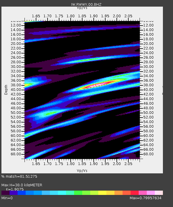
| Estimated Moho Depth: |
38.0 km |
| Estimated Crust Vp/Vs: |
1.91 |
| Assumed Crust Vp: |
6.159 km/s |
| Estimated Crust Vs: |
3.229 km/s |
| Estimated Crust Poisson's Ratio: |
0.31 |
|
| Radial Match: |
81.51275 % |
| Radial Bump: |
400 |
| Transverse Match: |
75.46594 % |
| Transverse Bump: |
368 |
| SOD ConfigId: |
1259291 |
| Insert Time: |
2015-11-30 17:47:17.523 +0000 |
| GWidth: |
2.5 |
| Max Bumps: |
400 |
| Tol: |
0.001 |
|

Signal To Noise
| Channel | StoN | STA | LTA |
| IW:RWWY:00:BHZ:20151116T16:59:21.664978Z | 8.404019 | 1.159497E-6 | 1.3796932E-7 |
| IW:RWWY:00:BH1:20151116T16:59:21.664978Z | 1.4528681 | 2.5895312E-7 | 1.7823581E-7 |
| IW:RWWY:00:BH2:20151116T16:59:21.664978Z | 2.2205253 | 4.4049025E-7 | 1.983721E-7 |
| Arrivals |
| Ps | 5.8 SECOND |
| PpPs | 17 SECOND |
| PsPs/PpSs | 23 SECOND |


