You are here: Home > Network List > TA - USArray Transportable Network (new EarthScope stations) Stations List
> Station D23K Nanushuk River, AK USA > Earthquake Result Viewer
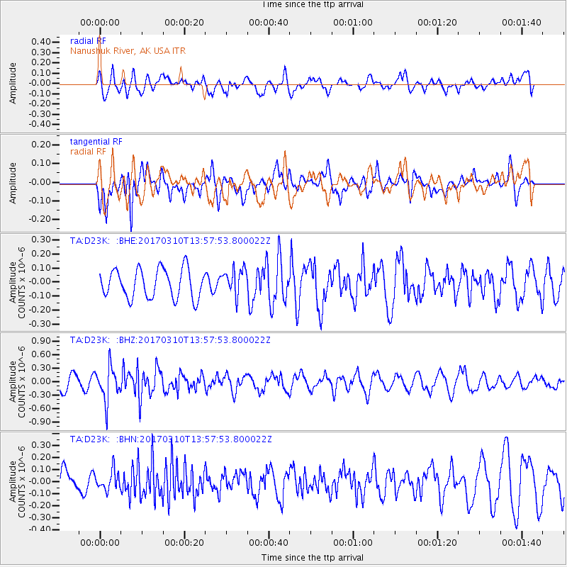
D23K Nanushuk River, AK USA - Earthquake Result Viewer
*The percent match for this event was below the threshold and hence no stack was calculated.
| Earthquake location: |
Near Coast Of Venezuela |
| Earthquake latitude/longitude: |
12.0/-69.6 |
| Earthquake time(UTC): |
2017/03/10 (069) 13:46:39 GMT |
| Earthquake Depth: |
10 km |
| Earthquake Magnitude: |
5.5 mb |
| Earthquake Catalog/Contributor: |
NEIC PDE/us |
|
| Network: |
TA USArray Transportable Network (new EarthScope stations) |
| Station: |
D23K Nanushuk River, AK USA |
| Lat/Lon: |
68.97 N/150.68 W |
| Elevation: |
406 m |
|
| Distance: |
75.7 deg |
| Az: |
338.404 deg |
| Baz: |
93.965 deg |
| Ray Param: |
$rayparam |
*The percent match for this event was below the threshold and hence was not used in the summary stack. |
|
| Radial Match: |
66.40124 % |
| Radial Bump: |
400 |
| Transverse Match: |
67.601135 % |
| Transverse Bump: |
400 |
| SOD ConfigId: |
11737051 |
| Insert Time: |
2019-04-26 22:08:58.963 +0000 |
| GWidth: |
2.5 |
| Max Bumps: |
400 |
| Tol: |
0.001 |
|
Signal To Noise
| Channel | StoN | STA | LTA |
| TA:D23K: :BHZ:20170310T13:57:53.800022Z | 2.3664012 | 3.820678E-7 | 1.614552E-7 |
| TA:D23K: :BHN:20170310T13:57:53.800022Z | 1.0559497 | 8.023394E-8 | 7.598273E-8 |
| TA:D23K: :BHE:20170310T13:57:53.800022Z | 0.91223603 | 9.475092E-8 | 1.03866675E-7 |
| Arrivals |
| Ps | |
| PpPs | |
| PsPs/PpSs | |


