You are here: Home > Network List > TA - USArray Transportable Network (new EarthScope stations) Stations List
> Station F26K Sheenjek River, AK, USA > Earthquake Result Viewer
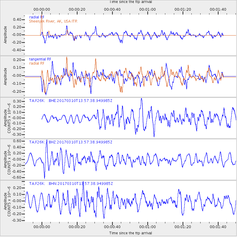
F26K Sheenjek River, AK, USA - Earthquake Result Viewer
*The percent match for this event was below the threshold and hence no stack was calculated.
| Earthquake location: |
Near Coast Of Venezuela |
| Earthquake latitude/longitude: |
12.0/-69.6 |
| Earthquake time(UTC): |
2017/03/10 (069) 13:46:39 GMT |
| Earthquake Depth: |
10 km |
| Earthquake Magnitude: |
5.5 mb |
| Earthquake Catalog/Contributor: |
NEIC PDE/us |
|
| Network: |
TA USArray Transportable Network (new EarthScope stations) |
| Station: |
F26K Sheenjek River, AK, USA |
| Lat/Lon: |
67.69 N/144.15 W |
| Elevation: |
683 m |
|
| Distance: |
73.2 deg |
| Az: |
337.391 deg |
| Baz: |
99.762 deg |
| Ray Param: |
$rayparam |
*The percent match for this event was below the threshold and hence was not used in the summary stack. |
|
| Radial Match: |
56.056 % |
| Radial Bump: |
400 |
| Transverse Match: |
63.094715 % |
| Transverse Bump: |
400 |
| SOD ConfigId: |
11737051 |
| Insert Time: |
2019-04-26 22:09:05.744 +0000 |
| GWidth: |
2.5 |
| Max Bumps: |
400 |
| Tol: |
0.001 |
|
Signal To Noise
| Channel | StoN | STA | LTA |
| TA:F26K: :BHZ:20170310T13:57:38.949985Z | 2.922267 | 3.0407938E-7 | 1.04055985E-7 |
| TA:F26K: :BHN:20170310T13:57:38.949985Z | 1.1556023 | 8.6944524E-8 | 7.523741E-8 |
| TA:F26K: :BHE:20170310T13:57:38.949985Z | 2.1146631 | 9.7582756E-8 | 4.6145768E-8 |
| Arrivals |
| Ps | |
| PpPs | |
| PsPs/PpSs | |


