You are here: Home > Network List > TA - USArray Transportable Network (new EarthScope stations) Stations List
> Station MDND Maddock, ND, USA > Earthquake Result Viewer
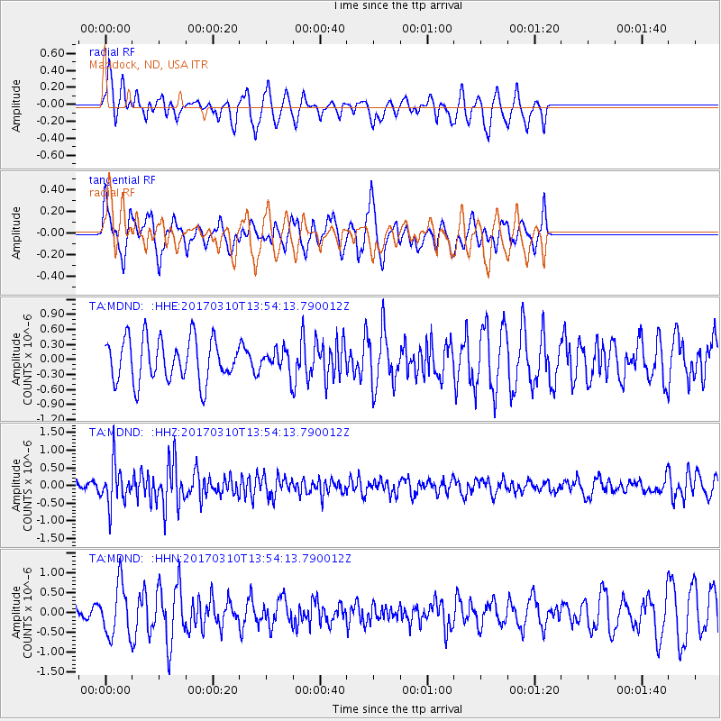
MDND Maddock, ND, USA - Earthquake Result Viewer
*The percent match for this event was below the threshold and hence no stack was calculated.
| Earthquake location: |
Near Coast Of Venezuela |
| Earthquake latitude/longitude: |
12.0/-69.6 |
| Earthquake time(UTC): |
2017/03/10 (069) 13:46:39 GMT |
| Earthquake Depth: |
10 km |
| Earthquake Magnitude: |
5.5 mb |
| Earthquake Catalog/Contributor: |
NEIC PDE/us |
|
| Network: |
TA USArray Transportable Network (new EarthScope stations) |
| Station: |
MDND Maddock, ND, USA |
| Lat/Lon: |
47.85 N/99.60 W |
| Elevation: |
479 m |
|
| Distance: |
43.7 deg |
| Az: |
330.815 deg |
| Baz: |
134.892 deg |
| Ray Param: |
$rayparam |
*The percent match for this event was below the threshold and hence was not used in the summary stack. |
|
| Radial Match: |
44.40676 % |
| Radial Bump: |
350 |
| Transverse Match: |
44.13559 % |
| Transverse Bump: |
393 |
| SOD ConfigId: |
11737051 |
| Insert Time: |
2019-04-26 22:09:26.011 +0000 |
| GWidth: |
2.5 |
| Max Bumps: |
400 |
| Tol: |
0.001 |
|
Signal To Noise
| Channel | StoN | STA | LTA |
| TA:MDND: :HHZ:20170310T13:54:13.790012Z | 2.7708259 | 5.618173E-7 | 2.0276167E-7 |
| TA:MDND: :HHN:20170310T13:54:13.790012Z | 1.238435 | 6.5079337E-7 | 5.254966E-7 |
| TA:MDND: :HHE:20170310T13:54:13.790012Z | 0.5043067 | 2.1447367E-7 | 4.252842E-7 |
| Arrivals |
| Ps | |
| PpPs | |
| PsPs/PpSs | |


