You are here: Home > Network List > CI - Caltech Regional Seismic Network Stations List
> Station MPM Manuel Prospect Mine, California, USA > Earthquake Result Viewer
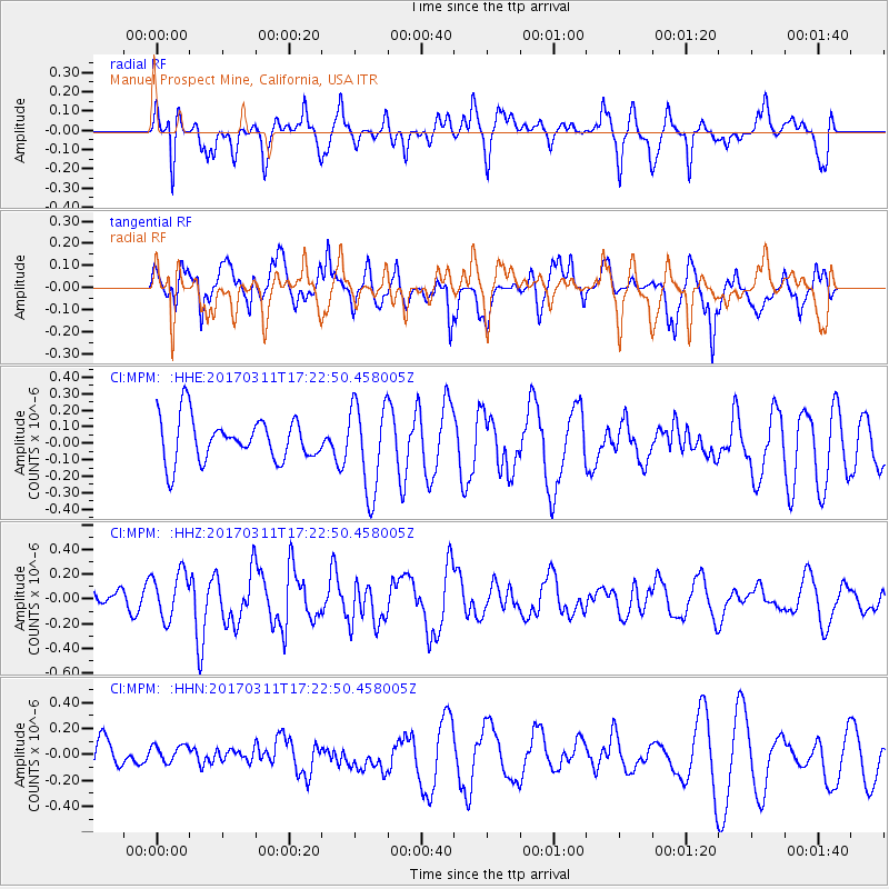
MPM Manuel Prospect Mine, California, USA - Earthquake Result Viewer
*The percent match for this event was below the threshold and hence no stack was calculated.
| Earthquake location: |
Kermadec Islands, New Zealand |
| Earthquake latitude/longitude: |
-30.6/-177.5 |
| Earthquake time(UTC): |
2017/03/11 (070) 17:10:38 GMT |
| Earthquake Depth: |
19 km |
| Earthquake Magnitude: |
5.5 mb |
| Earthquake Catalog/Contributor: |
NEIC PDE/us |
|
| Network: |
CI Caltech Regional Seismic Network |
| Station: |
MPM Manuel Prospect Mine, California, USA |
| Lat/Lon: |
36.06 N/117.49 W |
| Elevation: |
185 m |
|
| Distance: |
87.0 deg |
| Az: |
44.662 deg |
| Baz: |
228.385 deg |
| Ray Param: |
$rayparam |
*The percent match for this event was below the threshold and hence was not used in the summary stack. |
|
| Radial Match: |
61.991985 % |
| Radial Bump: |
342 |
| Transverse Match: |
72.96922 % |
| Transverse Bump: |
400 |
| SOD ConfigId: |
11737051 |
| Insert Time: |
2019-04-26 22:15:06.650 +0000 |
| GWidth: |
2.5 |
| Max Bumps: |
400 |
| Tol: |
0.001 |
|
Signal To Noise
| Channel | StoN | STA | LTA |
| CI:MPM: :HHZ:20170311T17:22:50.458005Z | 1.0513086 | 1.8707887E-7 | 1.7794858E-7 |
| CI:MPM: :HHN:20170311T17:22:50.458005Z | 0.46125033 | 7.293628E-8 | 1.5812732E-7 |
| CI:MPM: :HHE:20170311T17:22:50.458005Z | 2.1380484 | 2.750034E-7 | 1.2862355E-7 |
| Arrivals |
| Ps | |
| PpPs | |
| PsPs/PpSs | |


