You are here: Home > Network List > CI - Caltech Regional Seismic Network Stations List
> Station SVD Seven Oaks Dam, California, USA > Earthquake Result Viewer
SVD Seven Oaks Dam, California, USA - Earthquake Result Viewer
| Earthquake location: |
Southeast Of Loyalty Islands |
| Earthquake latitude/longitude: |
-22.3/170.9 |
| Earthquake time(UTC): |
1998/01/04 (004) 06:11:58 GMT |
| Earthquake Depth: |
101 km |
| Earthquake Magnitude: |
6.4 MB, 7.4 UNKNOWN, 7.3 ME |
| Earthquake Catalog/Contributor: |
WHDF/NEIC |
|
| Network: |
CI Caltech Regional Seismic Network |
| Station: |
SVD Seven Oaks Dam, California, USA |
| Lat/Lon: |
34.11 N/117.10 W |
| Elevation: |
574 m |
|
| Distance: |
88.5 deg |
| Az: |
52.127 deg |
| Baz: |
241.768 deg |
| Ray Param: |
0.042364545 |
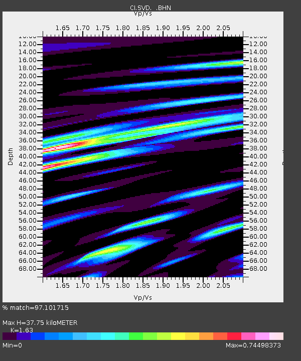
| Estimated Moho Depth: |
37.75 km |
| Estimated Crust Vp/Vs: |
1.63 |
| Assumed Crust Vp: |
6.276 km/s |
| Estimated Crust Vs: |
3.85 km/s |
| Estimated Crust Poisson's Ratio: |
0.20 |
|
| Radial Match: |
97.101715 % |
| Radial Bump: |
400 |
| Transverse Match: |
92.64458 % |
| Transverse Bump: |
400 |
| SOD ConfigId: |
3787 |
| Insert Time: |
2010-03-05 22:26:24.052 +0000 |
| GWidth: |
2.5 |
| Max Bumps: |
400 |
| Tol: |
0.001 |
|
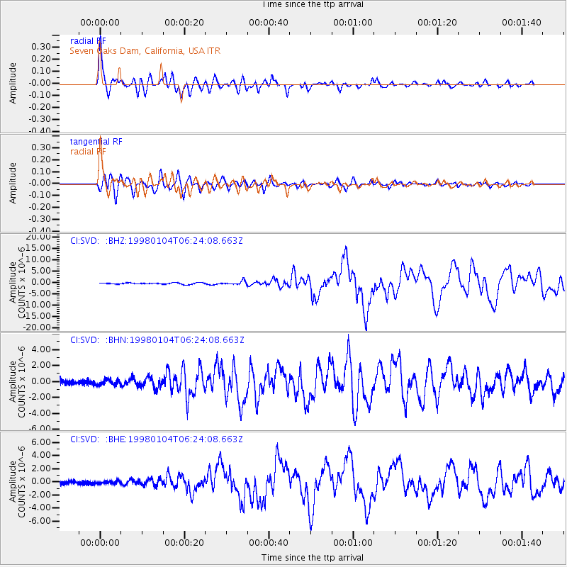
Signal To Noise
| Channel | StoN | STA | LTA |
| CI:SVD: :BHN:19980104T06:24:08.663Z | 1.1897979 | 3.594435E-7 | 3.0210467E-7 |
| CI:SVD: :BHE:19980104T06:24:08.663Z | 0.6840907 | 2.1499268E-7 | 3.1427513E-7 |
| CI:SVD: :BHZ:19980104T06:24:08.663Z | 2.7017918 | 8.165598E-7 | 3.0222898E-7 |
| Arrivals |
| Ps | 3.9 SECOND |
| PpPs | 15 SECOND |
| PsPs/PpSs | 19 SECOND |


