You are here: Home > Network List > TA - USArray Transportable Network (new EarthScope stations) Stations List
> Station O17K Koliganek, Bristol Bay, AK, USA > Earthquake Result Viewer
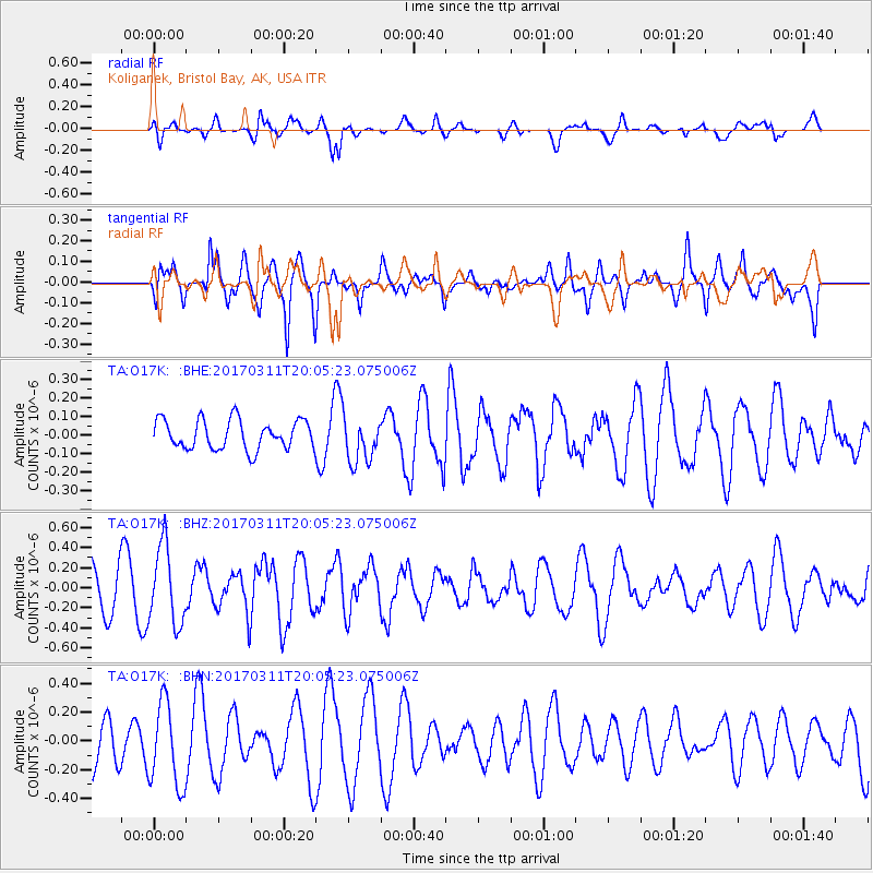
O17K Koliganek, Bristol Bay, AK, USA - Earthquake Result Viewer
*The percent match for this event was below the threshold and hence no stack was calculated.
| Earthquake location: |
Near East Coast Of Honshu, Japan |
| Earthquake latitude/longitude: |
37.5/141.5 |
| Earthquake time(UTC): |
2017/03/11 (070) 19:57:48 GMT |
| Earthquake Depth: |
44 km |
| Earthquake Magnitude: |
5.3 Mww |
| Earthquake Catalog/Contributor: |
NEIC PDE/us |
|
| Network: |
TA USArray Transportable Network (new EarthScope stations) |
| Station: |
O17K Koliganek, Bristol Bay, AK, USA |
| Lat/Lon: |
59.77 N/157.09 W |
| Elevation: |
156 m |
|
| Distance: |
44.3 deg |
| Az: |
39.502 deg |
| Baz: |
268.24 deg |
| Ray Param: |
$rayparam |
*The percent match for this event was below the threshold and hence was not used in the summary stack. |
|
| Radial Match: |
58.83567 % |
| Radial Bump: |
400 |
| Transverse Match: |
70.862946 % |
| Transverse Bump: |
400 |
| SOD ConfigId: |
11737051 |
| Insert Time: |
2019-04-26 22:34:08.676 +0000 |
| GWidth: |
2.5 |
| Max Bumps: |
400 |
| Tol: |
0.001 |
|
Signal To Noise
| Channel | StoN | STA | LTA |
| TA:O17K: :BHZ:20170311T20:05:23.075006Z | 1.9908854 | 3.8683717E-7 | 1.9430409E-7 |
| TA:O17K: :BHN:20170311T20:05:23.075006Z | 2.0505257 | 2.9238907E-7 | 1.4259226E-7 |
| TA:O17K: :BHE:20170311T20:05:23.075006Z | 1.5788435 | 1.237076E-7 | 7.8353295E-8 |
| Arrivals |
| Ps | |
| PpPs | |
| PsPs/PpSs | |


