You are here: Home > Network List > CI - Caltech Regional Seismic Network Stations List
> Station SVD Seven Oaks Dam, California, USA > Earthquake Result Viewer
SVD Seven Oaks Dam, California, USA - Earthquake Result Viewer
| Earthquake location: |
Samoa Islands Region |
| Earthquake latitude/longitude: |
-15.5/-172.1 |
| Earthquake time(UTC): |
2009/09/29 (272) 17:48:10 GMT |
| Earthquake Depth: |
18 km |
| Earthquake Magnitude: |
7.1 MB, 8.1 MS, 8.1 MW, 8.0 MW |
| Earthquake Catalog/Contributor: |
WHDF/NEIC |
|
| Network: |
CI Caltech Regional Seismic Network |
| Station: |
SVD Seven Oaks Dam, California, USA |
| Lat/Lon: |
34.11 N/117.10 W |
| Elevation: |
574 m |
|
| Distance: |
71.9 deg |
| Az: |
45.648 deg |
| Baz: |
236.19 deg |
| Ray Param: |
0.05400698 |
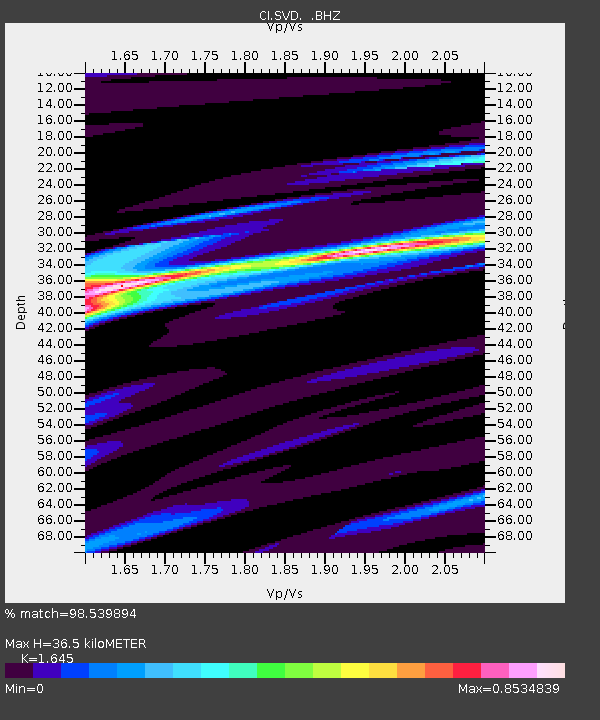
| Estimated Moho Depth: |
36.5 km |
| Estimated Crust Vp/Vs: |
1.64 |
| Assumed Crust Vp: |
6.276 km/s |
| Estimated Crust Vs: |
3.815 km/s |
| Estimated Crust Poisson's Ratio: |
0.21 |
|
| Radial Match: |
98.539894 % |
| Radial Bump: |
243 |
| Transverse Match: |
89.929375 % |
| Transverse Bump: |
400 |
| SOD ConfigId: |
2622 |
| Insert Time: |
2010-03-05 22:27:12.888 +0000 |
| GWidth: |
2.5 |
| Max Bumps: |
400 |
| Tol: |
0.001 |
|
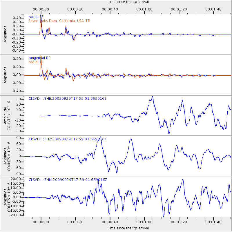
Signal To Noise
| Channel | StoN | STA | LTA |
| CI:SVD: :BHZ:20090929T17:59:01.669016Z | 15.19784 | 3.110777E-6 | 2.0468546E-7 |
| CI:SVD: :BHN:20090929T17:59:01.669016Z | 2.4098916 | 5.4844224E-7 | 2.2757963E-7 |
| CI:SVD: :BHE:20090929T17:59:01.669016Z | 3.2214231 | 1.0128244E-6 | 3.144028E-7 |
| Arrivals |
| Ps | 3.9 SECOND |
| PpPs | 15 SECOND |
| PsPs/PpSs | 19 SECOND |


