You are here: Home > Network List > CI - Caltech Regional Seismic Network Stations List
> Station FUR Furnace Creek, CA, USA > Earthquake Result Viewer
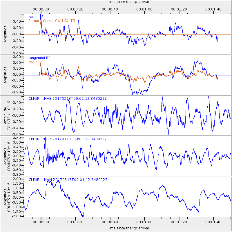
FUR Furnace Creek, CA, USA - Earthquake Result Viewer
*The percent match for this event was below the threshold and hence no stack was calculated.
| Earthquake location: |
Mariana Islands |
| Earthquake latitude/longitude: |
14.3/145.3 |
| Earthquake time(UTC): |
2017/03/13 (072) 08:49:06 GMT |
| Earthquake Depth: |
101 km |
| Earthquake Magnitude: |
5.5 Mi |
| Earthquake Catalog/Contributor: |
NEIC PDE/pt |
|
| Network: |
CI Caltech Regional Seismic Network |
| Station: |
FUR Furnace Creek, CA, USA |
| Lat/Lon: |
36.47 N/116.86 W |
| Elevation: |
-37.0 m |
|
| Distance: |
87.8 deg |
| Az: |
53.056 deg |
| Baz: |
286.029 deg |
| Ray Param: |
$rayparam |
*The percent match for this event was below the threshold and hence was not used in the summary stack. |
|
| Radial Match: |
38.37135 % |
| Radial Bump: |
400 |
| Transverse Match: |
17.144753 % |
| Transverse Bump: |
400 |
| SOD ConfigId: |
11737051 |
| Insert Time: |
2019-04-26 22:38:48.496 +0000 |
| GWidth: |
2.5 |
| Max Bumps: |
400 |
| Tol: |
0.001 |
|
Signal To Noise
| Channel | StoN | STA | LTA |
| CI:FUR: :HHZ:20170313T09:01:12.348022Z | 1.3251653 | 3.43396E-7 | 2.5913448E-7 |
| CI:FUR: :HHN:20170313T09:01:12.348022Z | 4.1372147 | 1.5425089E-6 | 3.7283755E-7 |
| CI:FUR: :HHE:20170313T09:01:12.348022Z | 0.6135503 | 1.567239E-7 | 2.5543775E-7 |
| Arrivals |
| Ps | |
| PpPs | |
| PsPs/PpSs | |


