You are here: Home > Network List > CI - Caltech Regional Seismic Network Stations List
> Station SVD Seven Oaks Dam, California, USA > Earthquake Result Viewer
SVD Seven Oaks Dam, California, USA - Earthquake Result Viewer
| Earthquake location: |
Tonga Islands |
| Earthquake latitude/longitude: |
-17.2/-173.9 |
| Earthquake time(UTC): |
2000/09/26 (270) 06:17:52 GMT |
| Earthquake Depth: |
56 km |
| Earthquake Magnitude: |
6.1 MB, 6.1 MS, 6.4 MW, 6.1 ME |
| Earthquake Catalog/Contributor: |
WHDF/NEIC |
|
| Network: |
CI Caltech Regional Seismic Network |
| Station: |
SVD Seven Oaks Dam, California, USA |
| Lat/Lon: |
34.11 N/117.10 W |
| Elevation: |
574 m |
|
| Distance: |
74.3 deg |
| Az: |
46.166 deg |
| Baz: |
236.208 deg |
| Ray Param: |
0.052296076 |
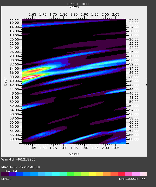
| Estimated Moho Depth: |
37.75 km |
| Estimated Crust Vp/Vs: |
1.64 |
| Assumed Crust Vp: |
6.276 km/s |
| Estimated Crust Vs: |
3.827 km/s |
| Estimated Crust Poisson's Ratio: |
0.20 |
|
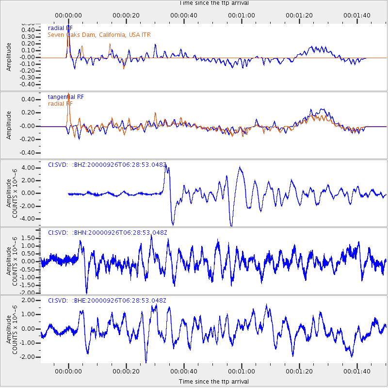
| Radial Match: |
90.218956 % |
| Radial Bump: |
400 |
| Transverse Match: |
77.03515 % |
| Transverse Bump: |
400 |
| SOD ConfigId: |
3744 |
| Insert Time: |
2010-03-05 22:27:48.439 +0000 |
| GWidth: |
2.5 |
| Max Bumps: |
400 |
| Tol: |
0.001 |
|
Signal To Noise
| Channel | StoN | STA | LTA |
| CI:SVD: :BHN:20000926T06:28:53.048Z | 2.07142 | 5.8695605E-7 | 2.8335927E-7 |
| CI:SVD: :BHE:20000926T06:28:53.048Z | 1.9398543 | 5.9764704E-7 | 3.0808863E-7 |
| CI:SVD: :BHZ:20000926T06:28:53.048Z | 13.197903 | 2.0598768E-6 | 1.5607608E-7 |
| Arrivals |
| Ps | 4.0 SECOND |
| PpPs | 15 SECOND |
| PsPs/PpSs | 19 SECOND |


