You are here: Home > Network List > TA - USArray Transportable Network (new EarthScope stations) Stations List
> Station R32K Eaglecrest, AK, USA > Earthquake Result Viewer
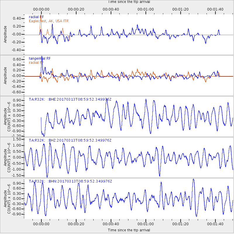
R32K Eaglecrest, AK, USA - Earthquake Result Viewer
*The percent match for this event was below the threshold and hence no stack was calculated.
| Earthquake location: |
Mariana Islands |
| Earthquake latitude/longitude: |
14.3/145.3 |
| Earthquake time(UTC): |
2017/03/13 (072) 08:49:06 GMT |
| Earthquake Depth: |
101 km |
| Earthquake Magnitude: |
5.5 Mi |
| Earthquake Catalog/Contributor: |
NEIC PDE/pt |
|
| Network: |
TA USArray Transportable Network (new EarthScope stations) |
| Station: |
R32K Eaglecrest, AK, USA |
| Lat/Lon: |
58.27 N/134.52 W |
| Elevation: |
386 m |
|
| Distance: |
72.8 deg |
| Az: |
33.028 deg |
| Baz: |
269.345 deg |
| Ray Param: |
$rayparam |
*The percent match for this event was below the threshold and hence was not used in the summary stack. |
|
| Radial Match: |
52.91517 % |
| Radial Bump: |
400 |
| Transverse Match: |
59.979 % |
| Transverse Bump: |
400 |
| SOD ConfigId: |
11737051 |
| Insert Time: |
2019-04-26 22:41:44.124 +0000 |
| GWidth: |
2.5 |
| Max Bumps: |
400 |
| Tol: |
0.001 |
|
Signal To Noise
| Channel | StoN | STA | LTA |
| TA:R32K: :BHZ:20170313T08:59:52.349976Z | 2.5903566 | 8.7803454E-7 | 3.3896282E-7 |
| TA:R32K: :BHN:20170313T08:59:52.349976Z | 1.8912684 | 6.55528E-7 | 3.466076E-7 |
| TA:R32K: :BHE:20170313T08:59:52.349976Z | 0.9551513 | 3.6473457E-7 | 3.8186053E-7 |
| Arrivals |
| Ps | |
| PpPs | |
| PsPs/PpSs | |


