You are here: Home > Network List > US - United States National Seismic Network Stations List
> Station MNTX Cornudas Mountains, Texas, USA > Earthquake Result Viewer
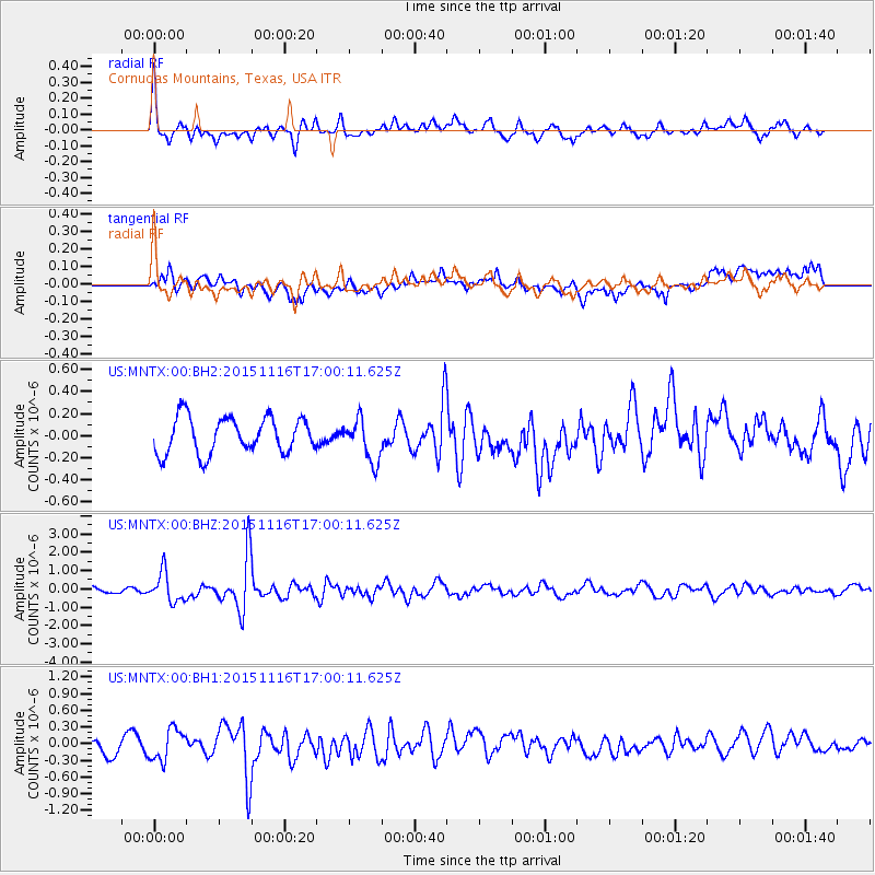
MNTX Cornudas Mountains, Texas, USA - Earthquake Result Viewer
*The percent match for this event was below the threshold and hence no stack was calculated.
| Earthquake location: |
Kuril Islands |
| Earthquake latitude/longitude: |
48.3/154.3 |
| Earthquake time(UTC): |
2015/11/16 (320) 16:49:15 GMT |
| Earthquake Depth: |
42 km |
| Earthquake Magnitude: |
5.8 MWB |
| Earthquake Catalog/Contributor: |
NEIC PDE/NEIC COMCAT |
|
| Network: |
US United States National Seismic Network |
| Station: |
MNTX Cornudas Mountains, Texas, USA |
| Lat/Lon: |
31.70 N/105.38 W |
| Elevation: |
404 m |
|
| Distance: |
73.3 deg |
| Az: |
61.083 deg |
| Baz: |
316.707 deg |
| Ray Param: |
$rayparam |
*The percent match for this event was below the threshold and hence was not used in the summary stack. |
|
| Radial Match: |
72.47031 % |
| Radial Bump: |
400 |
| Transverse Match: |
55.65793 % |
| Transverse Bump: |
400 |
| SOD ConfigId: |
1259291 |
| Insert Time: |
2015-11-30 17:54:10.216 +0000 |
| GWidth: |
2.5 |
| Max Bumps: |
400 |
| Tol: |
0.001 |
|
Signal To Noise
| Channel | StoN | STA | LTA |
| US:MNTX:00:BHZ:20151116T17:00:11.625Z | 4.404141 | 7.989207E-7 | 1.8140217E-7 |
| US:MNTX:00:BH1:20151116T17:00:11.625Z | 1.8329824 | 2.815606E-7 | 1.536079E-7 |
| US:MNTX:00:BH2:20151116T17:00:11.625Z | 1.1541454 | 1.8728512E-7 | 1.622717E-7 |
| Arrivals |
| Ps | |
| PpPs | |
| PsPs/PpSs | |


