You are here: Home > Network List > UW - Pacific Northwest Regional Seismic Network Stations List
> Station YACT Amboy, WA, USA > Earthquake Result Viewer
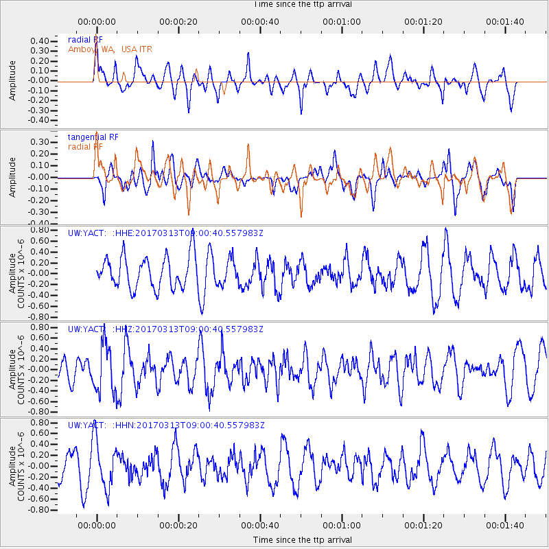
YACT Amboy, WA, USA - Earthquake Result Viewer
*The percent match for this event was below the threshold and hence no stack was calculated.
| Earthquake location: |
Mariana Islands |
| Earthquake latitude/longitude: |
14.3/145.3 |
| Earthquake time(UTC): |
2017/03/13 (072) 08:49:06 GMT |
| Earthquake Depth: |
101 km |
| Earthquake Magnitude: |
5.5 Mi |
| Earthquake Catalog/Contributor: |
NEIC PDE/pt |
|
| Network: |
UW Pacific Northwest Regional Seismic Network |
| Station: |
YACT Amboy, WA, USA |
| Lat/Lon: |
45.93 N/122.42 W |
| Elevation: |
211 m |
|
| Distance: |
81.4 deg |
| Az: |
44.851 deg |
| Baz: |
281.593 deg |
| Ray Param: |
$rayparam |
*The percent match for this event was below the threshold and hence was not used in the summary stack. |
|
| Radial Match: |
61.998283 % |
| Radial Bump: |
400 |
| Transverse Match: |
64.58757 % |
| Transverse Bump: |
400 |
| SOD ConfigId: |
11737051 |
| Insert Time: |
2019-04-26 22:42:26.107 +0000 |
| GWidth: |
2.5 |
| Max Bumps: |
400 |
| Tol: |
0.001 |
|
Signal To Noise
| Channel | StoN | STA | LTA |
| UW:YACT: :HHZ:20170313T09:00:40.557983Z | 1.5000944 | 4.567025E-7 | 3.0444917E-7 |
| UW:YACT: :HHN:20170313T09:00:40.557983Z | 2.2965176 | 4.5887026E-7 | 1.9981135E-7 |
| UW:YACT: :HHE:20170313T09:00:40.557983Z | 0.7833441 | 2.3030064E-7 | 2.9399678E-7 |
| Arrivals |
| Ps | |
| PpPs | |
| PsPs/PpSs | |


