You are here: Home > Network List > US - United States National Seismic Network Stations List
> Station WMOK Wichita Mountains, Oklahoma, USA > Earthquake Result Viewer
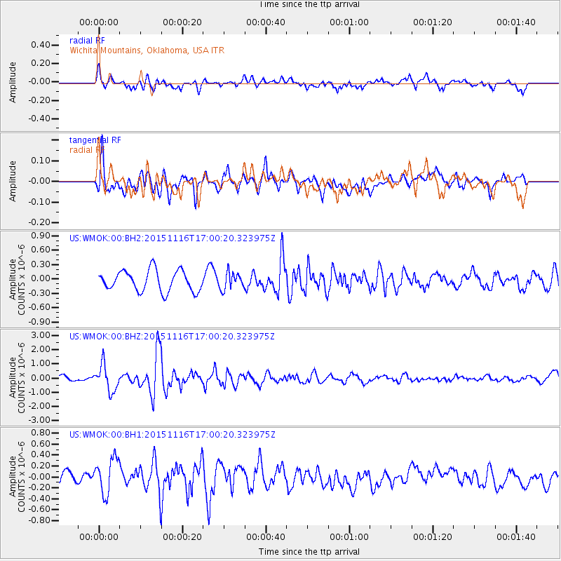
WMOK Wichita Mountains, Oklahoma, USA - Earthquake Result Viewer
*The percent match for this event was below the threshold and hence no stack was calculated.
| Earthquake location: |
Kuril Islands |
| Earthquake latitude/longitude: |
48.3/154.3 |
| Earthquake time(UTC): |
2015/11/16 (320) 16:49:15 GMT |
| Earthquake Depth: |
42 km |
| Earthquake Magnitude: |
5.8 MWB |
| Earthquake Catalog/Contributor: |
NEIC PDE/NEIC COMCAT |
|
| Network: |
US United States National Seismic Network |
| Station: |
WMOK Wichita Mountains, Oklahoma, USA |
| Lat/Lon: |
34.74 N/98.78 W |
| Elevation: |
486 m |
|
| Distance: |
74.8 deg |
| Az: |
54.71 deg |
| Baz: |
318.56 deg |
| Ray Param: |
$rayparam |
*The percent match for this event was below the threshold and hence was not used in the summary stack. |
|
| Radial Match: |
57.875626 % |
| Radial Bump: |
400 |
| Transverse Match: |
61.57261 % |
| Transverse Bump: |
400 |
| SOD ConfigId: |
1259291 |
| Insert Time: |
2015-11-30 17:54:55.027 +0000 |
| GWidth: |
2.5 |
| Max Bumps: |
400 |
| Tol: |
0.001 |
|
Signal To Noise
| Channel | StoN | STA | LTA |
| US:WMOK:00:BHZ:20151116T17:00:20.323975Z | 5.2481003 | 9.4237345E-7 | 1.7956468E-7 |
| US:WMOK:00:BH1:20151116T17:00:20.323975Z | 1.9164989 | 3.3890302E-7 | 1.7683445E-7 |
| US:WMOK:00:BH2:20151116T17:00:20.323975Z | 0.80922073 | 1.7479027E-7 | 2.1599827E-7 |
| Arrivals |
| Ps | |
| PpPs | |
| PsPs/PpSs | |


