You are here: Home > Network List > UU - University of Utah Regional Network Stations List
> Station KNB Kanab, UT, USA > Earthquake Result Viewer
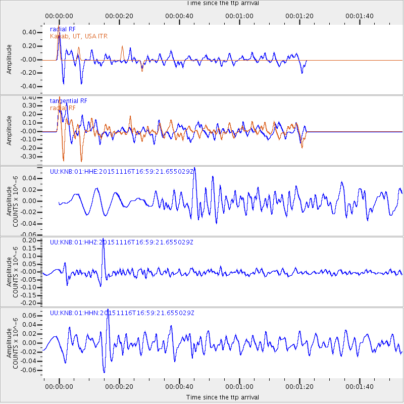
KNB Kanab, UT, USA - Earthquake Result Viewer
*The percent match for this event was below the threshold and hence no stack was calculated.
| Earthquake location: |
Kuril Islands |
| Earthquake latitude/longitude: |
48.3/154.3 |
| Earthquake time(UTC): |
2015/11/16 (320) 16:49:15 GMT |
| Earthquake Depth: |
42 km |
| Earthquake Magnitude: |
5.8 MWB |
| Earthquake Catalog/Contributor: |
NEIC PDE/NEIC COMCAT |
|
| Network: |
UU University of Utah Regional Network |
| Station: |
KNB Kanab, UT, USA |
| Lat/Lon: |
37.02 N/112.82 W |
| Elevation: |
1715 m |
|
| Distance: |
65.2 deg |
| Az: |
61.69 deg |
| Baz: |
312.734 deg |
| Ray Param: |
$rayparam |
*The percent match for this event was below the threshold and hence was not used in the summary stack. |
|
| Radial Match: |
70.22488 % |
| Radial Bump: |
316 |
| Transverse Match: |
65.35217 % |
| Transverse Bump: |
364 |
| SOD ConfigId: |
1259291 |
| Insert Time: |
2015-11-30 17:55:58.436 +0000 |
| GWidth: |
2.5 |
| Max Bumps: |
400 |
| Tol: |
0.001 |
|
Signal To Noise
| Channel | StoN | STA | LTA |
| UU:KNB:01:HHZ:20151116T16:59:21.655029Z | 3.1928804 | 3.2389263E-8 | 1.0144214E-8 |
| UU:KNB:01:HHN:20151116T16:59:21.655029Z | 1.7329377 | 2.1051505E-8 | 1.2147873E-8 |
| UU:KNB:01:HHE:20151116T16:59:21.655029Z | 0.6864489 | 8.325273E-9 | 1.2128031E-8 |
| Arrivals |
| Ps | |
| PpPs | |
| PsPs/PpSs | |


