You are here: Home > Network List > WY - Yellowstone Wyoming Seismic Network Stations List
> Station YHH Holmes Hill, YNP, WY, USA > Earthquake Result Viewer
YHH Holmes Hill, YNP, WY, USA - Earthquake Result Viewer
*The percent match for this event was below the threshold and hence no stack was calculated.
| Earthquake location: |
Kuril Islands |
| Earthquake latitude/longitude: |
48.3/154.3 |
| Earthquake time(UTC): |
2015/11/16 (320) 16:49:15 GMT |
| Earthquake Depth: |
42 km |
| Earthquake Magnitude: |
5.8 MWB |
| Earthquake Catalog/Contributor: |
NEIC PDE/NEIC COMCAT |
|
| Network: |
WY Yellowstone Wyoming Seismic Network |
| Station: |
YHH Holmes Hill, YNP, WY, USA |
| Lat/Lon: |
44.79 N/110.85 W |
| Elevation: |
2717 m |
|
| Distance: |
61.2 deg |
| Az: |
54.079 deg |
| Baz: |
310.585 deg |
| Ray Param: |
$rayparam |
*The percent match for this event was below the threshold and hence was not used in the summary stack. |
|
| Radial Match: |
77.21698 % |
| Radial Bump: |
400 |
| Transverse Match: |
72.44566 % |
| Transverse Bump: |
399 |
| SOD ConfigId: |
1259291 |
| Insert Time: |
2015-11-30 17:57:46.551 +0000 |
| GWidth: |
2.5 |
| Max Bumps: |
400 |
| Tol: |
0.001 |
|
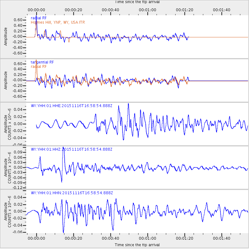
Signal To Noise
| Channel | StoN | STA | LTA |
| WY:YHH:01:HHZ:20151116T16:58:54.888Z | 7.1539693 | 2.459044E-8 | 3.4373142E-9 |
| WY:YHH:01:HHN:20151116T16:58:54.888Z | 1.4344709 | 1.3527489E-8 | 9.430299E-9 |
| WY:YHH:01:HHE:20151116T16:58:54.888Z | 2.0126717 | 1.3214538E-8 | 6.5656702E-9 |
| Arrivals |
| Ps | |
| PpPs | |
| PsPs/PpSs | |


