You are here: Home > Network List > TA - USArray Transportable Network (new EarthScope stations) Stations List
> Station A21K Barrow, AK, USA > Earthquake Result Viewer
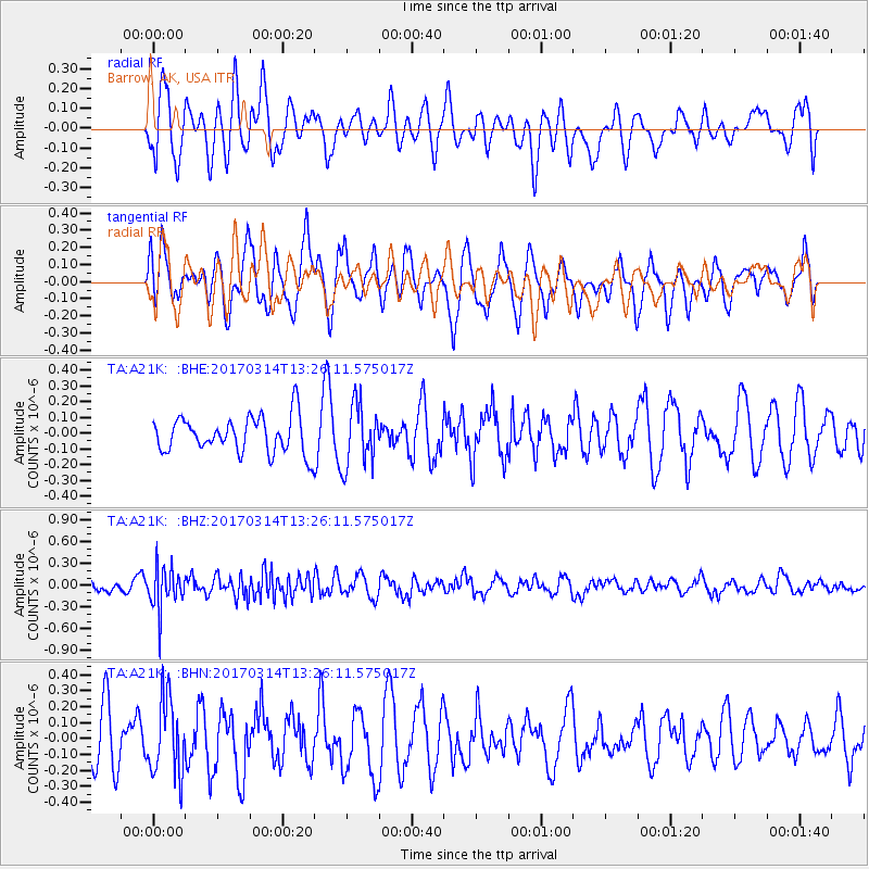
A21K Barrow, AK, USA - Earthquake Result Viewer
*The percent match for this event was below the threshold and hence no stack was calculated.
| Earthquake location: |
Off W Coast Of Northern Sumatra |
| Earthquake latitude/longitude: |
3.6/95.9 |
| Earthquake time(UTC): |
2017/03/14 (073) 13:13:38 GMT |
| Earthquake Depth: |
41 km |
| Earthquake Magnitude: |
5.5 mb |
| Earthquake Catalog/Contributor: |
NEIC PDE/us |
|
| Network: |
TA USArray Transportable Network (new EarthScope stations) |
| Station: |
A21K Barrow, AK, USA |
| Lat/Lon: |
71.32 N/156.62 W |
| Elevation: |
577 m |
|
| Distance: |
92.1 deg |
| Az: |
17.905 deg |
| Baz: |
287.762 deg |
| Ray Param: |
$rayparam |
*The percent match for this event was below the threshold and hence was not used in the summary stack. |
|
| Radial Match: |
47.89399 % |
| Radial Bump: |
400 |
| Transverse Match: |
67.01956 % |
| Transverse Bump: |
400 |
| SOD ConfigId: |
11737051 |
| Insert Time: |
2019-04-26 23:02:57.570 +0000 |
| GWidth: |
2.5 |
| Max Bumps: |
400 |
| Tol: |
0.001 |
|
Signal To Noise
| Channel | StoN | STA | LTA |
| TA:A21K: :BHZ:20170314T13:26:11.575017Z | 3.5099845 | 2.9741275E-7 | 8.473335E-8 |
| TA:A21K: :BHN:20170314T13:26:11.575017Z | 1.5387427 | 2.3928783E-7 | 1.5550867E-7 |
| TA:A21K: :BHE:20170314T13:26:11.575017Z | 1.6257299 | 1.9064767E-7 | 1.1726897E-7 |
| Arrivals |
| Ps | |
| PpPs | |
| PsPs/PpSs | |


