You are here: Home > Network List > WY - Yellowstone Wyoming Seismic Network Stations List
> Station YHR Hawk's Rest, WY, USA > Earthquake Result Viewer
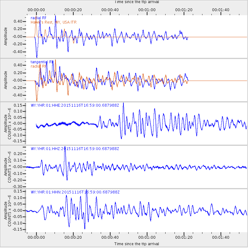
YHR Hawk's Rest, WY, USA - Earthquake Result Viewer
*The percent match for this event was below the threshold and hence no stack was calculated.
| Earthquake location: |
Kuril Islands |
| Earthquake latitude/longitude: |
48.3/154.3 |
| Earthquake time(UTC): |
2015/11/16 (320) 16:49:15 GMT |
| Earthquake Depth: |
42 km |
| Earthquake Magnitude: |
5.8 MWB |
| Earthquake Catalog/Contributor: |
NEIC PDE/NEIC COMCAT |
|
| Network: |
WY Yellowstone Wyoming Seismic Network |
| Station: |
YHR Hawk's Rest, WY, USA |
| Lat/Lon: |
44.11 N/110.08 W |
| Elevation: |
2976 m |
|
| Distance: |
62.0 deg |
| Az: |
54.255 deg |
| Baz: |
311.206 deg |
| Ray Param: |
$rayparam |
*The percent match for this event was below the threshold and hence was not used in the summary stack. |
|
| Radial Match: |
89.44681 % |
| Radial Bump: |
400 |
| Transverse Match: |
76.28481 % |
| Transverse Bump: |
400 |
| SOD ConfigId: |
1259291 |
| Insert Time: |
2015-11-30 17:58:25.224 +0000 |
| GWidth: |
2.5 |
| Max Bumps: |
400 |
| Tol: |
0.001 |
|
Signal To Noise
| Channel | StoN | STA | LTA |
| WY:YHR:01:HHZ:20151116T16:59:00.687988Z | 9.244352 | 5.1986664E-8 | 5.623613E-9 |
| WY:YHR:01:HHN:20151116T16:59:00.687988Z | 2.0041351 | 2.7237238E-8 | 1.3590519E-8 |
| WY:YHR:01:HHE:20151116T16:59:00.687988Z | 2.0243433 | 2.2113737E-8 | 1.0923906E-8 |
| Arrivals |
| Ps | |
| PpPs | |
| PsPs/PpSs | |


