You are here: Home > Network List > CI - Caltech Regional Seismic Network Stations List
> Station DAN DAN, Needles, CA, USA > Earthquake Result Viewer
DAN DAN, Needles, CA, USA - Earthquake Result Viewer

| Earthquake location: |
Kodiak Island Region, Alaska |
| Earthquake latitude/longitude: |
57.4/-154.5 |
| Earthquake time(UTC): |
1999/12/06 (340) 23:12:33 GMT |
| Earthquake Depth: |
66 km |
| Earthquake Magnitude: |
6.8 MB, 7.0 MW, 7.0 ML |
| Earthquake Catalog/Contributor: |
WHDF/NEIC |
|
| Network: |
CI Caltech Regional Seismic Network |
| Station: |
DAN DAN, Needles, CA, USA |
| Lat/Lon: |
34.64 N/115.38 W |
| Elevation: |
428 m |
|
| Distance: |
34.7 deg |
| Az: |
114.027 deg |
| Baz: |
323.17 deg |
| Ray Param: |
0.07741857 |
| Estimated Moho Depth: |
28.25 km |
| Estimated Crust Vp/Vs: |
1.67 |
| Assumed Crust Vp: |
6.276 km/s |
| Estimated Crust Vs: |
3.758 km/s |
| Estimated Crust Poisson's Ratio: |
0.22 |
|
| Radial Match: |
95.20002 % |
| Radial Bump: |
376 |
| Transverse Match: |
86.82552 % |
| Transverse Bump: |
400 |
| SOD ConfigId: |
3787 |
| Insert Time: |
2010-02-26 01:04:52.946 +0000 |
| GWidth: |
2.5 |
| Max Bumps: |
400 |
| Tol: |
0.001 |
|
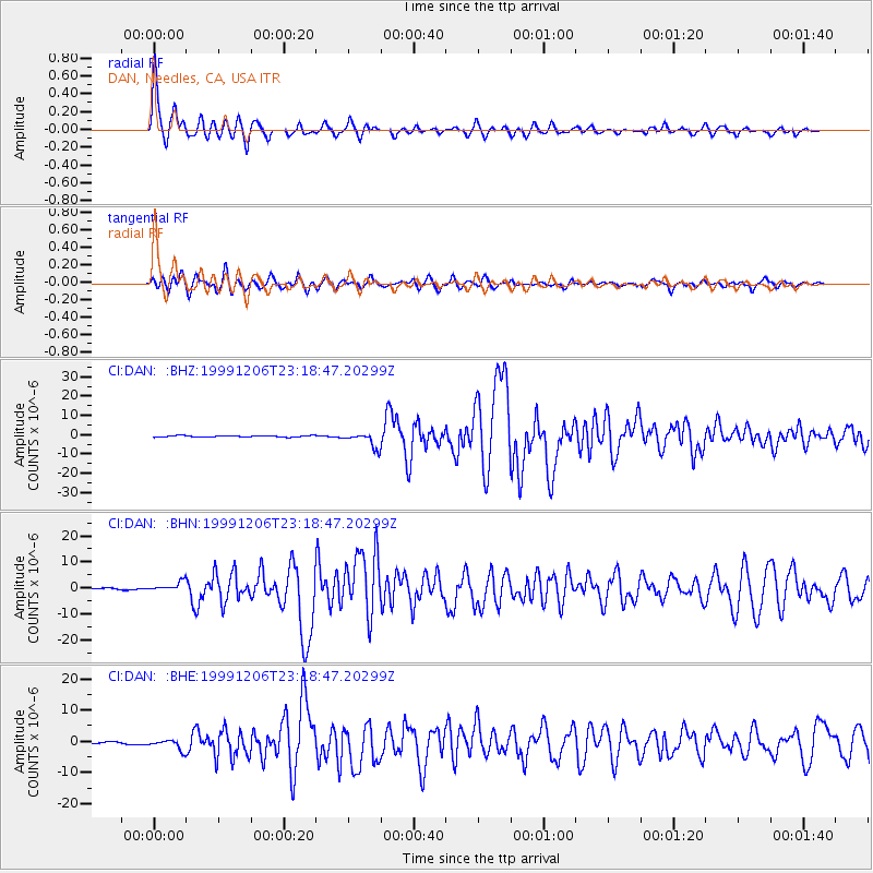
Signal To Noise
| Channel | StoN | STA | LTA |
| CI:DAN: :BHN:19991206T23:18:47.20299Z | 8.047669 | 1.8496393E-6 | 2.2983541E-7 |
| CI:DAN: :BHE:19991206T23:18:47.20299Z | 4.6453705 | 1.5705912E-6 | 3.3809818E-7 |
| CI:DAN: :BHZ:19991206T23:18:47.20299Z | 11.067578 | 3.921529E-6 | 3.5432583E-7 |
| Arrivals |
| Ps | 3.3 SECOND |
| PpPs | 11 SECOND |
| PsPs/PpSs | 14 SECOND |


