You are here: Home > Network List > TA - USArray Transportable Network (new EarthScope stations) Stations List
> Station R32K Eaglecrest, AK, USA > Earthquake Result Viewer
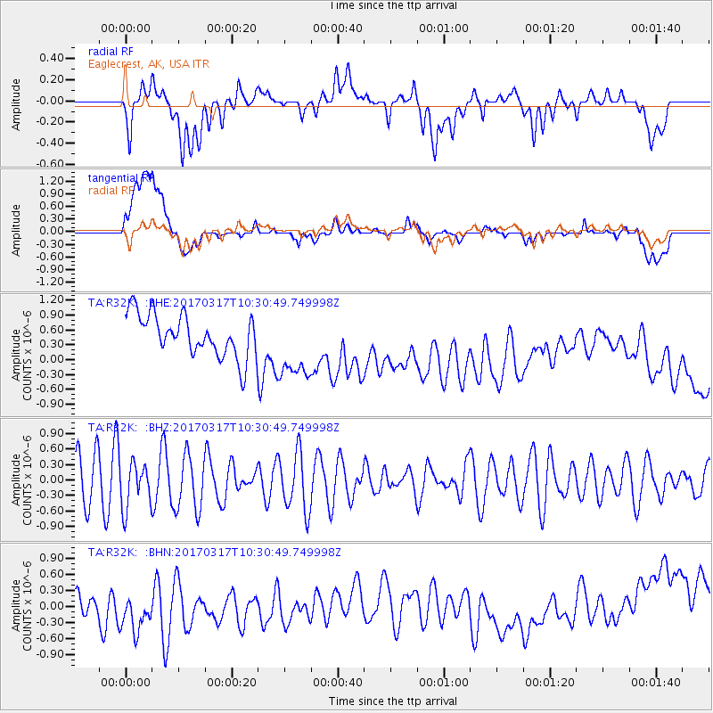
R32K Eaglecrest, AK, USA - Earthquake Result Viewer
*The percent match for this event was below the threshold and hence no stack was calculated.
| Earthquake location: |
South Of Fiji Islands |
| Earthquake latitude/longitude: |
-23.6/-176.8 |
| Earthquake time(UTC): |
2017/03/17 (076) 10:18:39 GMT |
| Earthquake Depth: |
109 km |
| Earthquake Magnitude: |
5.5 mb |
| Earthquake Catalog/Contributor: |
NEIC PDE/us |
|
| Network: |
TA USArray Transportable Network (new EarthScope stations) |
| Station: |
R32K Eaglecrest, AK, USA |
| Lat/Lon: |
58.27 N/134.52 W |
| Elevation: |
386 m |
|
| Distance: |
88.8 deg |
| Az: |
20.816 deg |
| Baz: |
218.091 deg |
| Ray Param: |
$rayparam |
*The percent match for this event was below the threshold and hence was not used in the summary stack. |
|
| Radial Match: |
10.85456 % |
| Radial Bump: |
400 |
| Transverse Match: |
14.868072 % |
| Transverse Bump: |
400 |
| SOD ConfigId: |
11737051 |
| Insert Time: |
2019-04-26 23:13:45.203 +0000 |
| GWidth: |
2.5 |
| Max Bumps: |
400 |
| Tol: |
0.001 |
|
Signal To Noise
| Channel | StoN | STA | LTA |
| TA:R32K: :BHZ:20170317T10:30:49.749998Z | 1.1070131 | 4.369488E-7 | 3.9470967E-7 |
| TA:R32K: :BHN:20170317T10:30:49.749998Z | 1.5190622 | 6.82046E-7 | 4.489915E-7 |
| TA:R32K: :BHE:20170317T10:30:49.749998Z | 1.6818085 | 7.222752E-7 | 4.2946343E-7 |
| Arrivals |
| Ps | |
| PpPs | |
| PsPs/PpSs | |


