You are here: Home > Network List > TA - USArray Transportable Network (new EarthScope stations) Stations List
> Station A21K Barrow, AK, USA > Earthquake Result Viewer
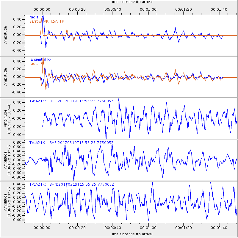
A21K Barrow, AK, USA - Earthquake Result Viewer
*The percent match for this event was below the threshold and hence no stack was calculated.
| Earthquake location: |
Solomon Islands |
| Earthquake latitude/longitude: |
-8.1/160.7 |
| Earthquake time(UTC): |
2017/03/19 (078) 15:43:25 GMT |
| Earthquake Depth: |
4.2 km |
| Earthquake Magnitude: |
6.0 Mww |
| Earthquake Catalog/Contributor: |
NEIC PDE/us |
|
| Network: |
TA USArray Transportable Network (new EarthScope stations) |
| Station: |
A21K Barrow, AK, USA |
| Lat/Lon: |
71.32 N/156.62 W |
| Elevation: |
577 m |
|
| Distance: |
84.2 deg |
| Az: |
12.674 deg |
| Baz: |
222.391 deg |
| Ray Param: |
$rayparam |
*The percent match for this event was below the threshold and hence was not used in the summary stack. |
|
| Radial Match: |
77.81697 % |
| Radial Bump: |
400 |
| Transverse Match: |
67.63385 % |
| Transverse Bump: |
400 |
| SOD ConfigId: |
11737051 |
| Insert Time: |
2019-04-26 23:20:11.422 +0000 |
| GWidth: |
2.5 |
| Max Bumps: |
400 |
| Tol: |
0.001 |
|
Signal To Noise
| Channel | StoN | STA | LTA |
| TA:A21K: :BHZ:20170319T15:55:25.775005Z | 1.8281839 | 2.2386534E-7 | 1.2245232E-7 |
| TA:A21K: :BHN:20170319T15:55:25.775005Z | 1.4896927 | 1.8724226E-7 | 1.2569187E-7 |
| TA:A21K: :BHE:20170319T15:55:25.775005Z | 1.9560661 | 1.9455453E-7 | 9.946214E-8 |
| Arrivals |
| Ps | |
| PpPs | |
| PsPs/PpSs | |


