You are here: Home > Network List > TA - USArray Transportable Network (new EarthScope stations) Stations List
> Station I23K Minto, Yukon-Koyukuk, AK, USA > Earthquake Result Viewer
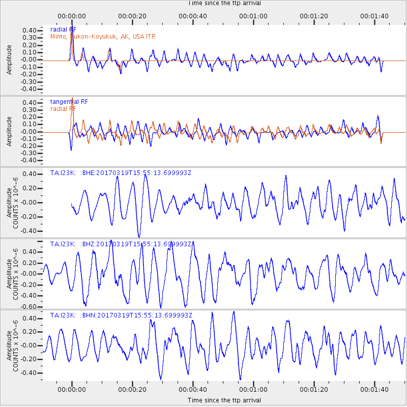
I23K Minto, Yukon-Koyukuk, AK, USA - Earthquake Result Viewer
*The percent match for this event was below the threshold and hence no stack was calculated.
| Earthquake location: |
Solomon Islands |
| Earthquake latitude/longitude: |
-8.1/160.7 |
| Earthquake time(UTC): |
2017/03/19 (078) 15:43:25 GMT |
| Earthquake Depth: |
4.2 km |
| Earthquake Magnitude: |
6.0 Mww |
| Earthquake Catalog/Contributor: |
NEIC PDE/us |
|
| Network: |
TA USArray Transportable Network (new EarthScope stations) |
| Station: |
I23K Minto, Yukon-Koyukuk, AK, USA |
| Lat/Lon: |
65.15 N/149.36 W |
| Elevation: |
149 m |
|
| Distance: |
81.8 deg |
| Az: |
19.061 deg |
| Baz: |
229.914 deg |
| Ray Param: |
$rayparam |
*The percent match for this event was below the threshold and hence was not used in the summary stack. |
|
| Radial Match: |
65.29732 % |
| Radial Bump: |
400 |
| Transverse Match: |
58.654465 % |
| Transverse Bump: |
400 |
| SOD ConfigId: |
11737051 |
| Insert Time: |
2019-04-26 23:20:19.616 +0000 |
| GWidth: |
2.5 |
| Max Bumps: |
400 |
| Tol: |
0.001 |
|
Signal To Noise
| Channel | StoN | STA | LTA |
| TA:I23K: :BHZ:20170319T15:55:13.699993Z | 2.7200792 | 3.2440784E-7 | 1.1926412E-7 |
| TA:I23K: :BHN:20170319T15:55:13.699993Z | 0.9547403 | 1.6456724E-7 | 1.7236859E-7 |
| TA:I23K: :BHE:20170319T15:55:13.699993Z | 0.4500114 | 8.969832E-8 | 1.9932455E-7 |
| Arrivals |
| Ps | |
| PpPs | |
| PsPs/PpSs | |


