You are here: Home > Network List > GS - US Geological Survey Networks Stations List
> Station KAN10 Keim Farm, Anthony, KS, USA > Earthquake Result Viewer
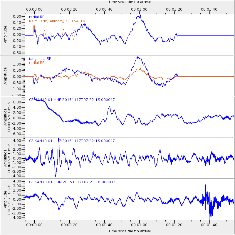
KAN10 Keim Farm, Anthony, KS, USA - Earthquake Result Viewer
*The percent match for this event was below the threshold and hence no stack was calculated.
| Earthquake location: |
Greece |
| Earthquake latitude/longitude: |
38.8/20.6 |
| Earthquake time(UTC): |
2015/11/17 (321) 07:10:08 GMT |
| Earthquake Depth: |
11 km |
| Earthquake Magnitude: |
6.5 MWB |
| Earthquake Catalog/Contributor: |
NEIC PDE/NEIC COMCAT |
|
| Network: |
GS US Geological Survey Networks |
| Station: |
KAN10 Keim Farm, Anthony, KS, USA |
| Lat/Lon: |
37.12 N/98.10 W |
| Elevation: |
417 m |
|
| Distance: |
85.7 deg |
| Az: |
315.298 deg |
| Baz: |
43.481 deg |
| Ray Param: |
$rayparam |
*The percent match for this event was below the threshold and hence was not used in the summary stack. |
|
| Radial Match: |
57.399258 % |
| Radial Bump: |
400 |
| Transverse Match: |
44.040443 % |
| Transverse Bump: |
400 |
| SOD ConfigId: |
1259291 |
| Insert Time: |
2015-12-01 07:54:54.766 +0000 |
| GWidth: |
2.5 |
| Max Bumps: |
400 |
| Tol: |
0.001 |
|
Signal To Noise
| Channel | StoN | STA | LTA |
| GS:KAN10:01:HHZ:20151117T07:22:16.00001Z | 4.5860977 | 1.0302833E-6 | 2.2465359E-7 |
| GS:KAN10:01:HHN:20151117T07:22:16.00001Z | 1.1215174 | 2.2402603E-6 | 1.997526E-6 |
| GS:KAN10:01:HHE:20151117T07:22:16.00001Z | 1.2324376 | 3.8987237E-6 | 3.163425E-6 |
| Arrivals |
| Ps | |
| PpPs | |
| PsPs/PpSs | |


