You are here: Home > Network List > IU - Global Seismograph Network (GSN - IRIS/USGS) Stations List
> Station FURI Mt. Furi, Ethiopia > Earthquake Result Viewer
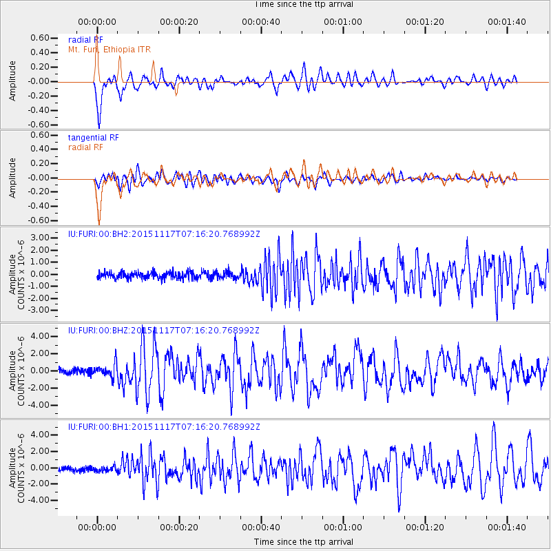
FURI Mt. Furi, Ethiopia - Earthquake Result Viewer
*The percent match for this event was below the threshold and hence no stack was calculated.
| Earthquake location: |
Greece |
| Earthquake latitude/longitude: |
38.8/20.6 |
| Earthquake time(UTC): |
2015/11/17 (321) 07:10:08 GMT |
| Earthquake Depth: |
11 km |
| Earthquake Magnitude: |
6.5 MWB |
| Earthquake Catalog/Contributor: |
NEIC PDE/NEIC COMCAT |
|
| Network: |
IU Global Seismograph Network (GSN - IRIS/USGS) |
| Station: |
FURI Mt. Furi, Ethiopia |
| Lat/Lon: |
8.90 N/38.68 E |
| Elevation: |
2570 m |
|
| Distance: |
33.9 deg |
| Az: |
146.548 deg |
| Baz: |
334.14 deg |
| Ray Param: |
$rayparam |
*The percent match for this event was below the threshold and hence was not used in the summary stack. |
|
| Radial Match: |
85.34554 % |
| Radial Bump: |
400 |
| Transverse Match: |
72.684326 % |
| Transverse Bump: |
400 |
| SOD ConfigId: |
1259291 |
| Insert Time: |
2015-12-01 07:56:48.465 +0000 |
| GWidth: |
2.5 |
| Max Bumps: |
400 |
| Tol: |
0.001 |
|
Signal To Noise
| Channel | StoN | STA | LTA |
| IU:FURI:00:BHZ:20151117T07:16:20.768992Z | 2.8111646 | 7.788815E-7 | 2.770672E-7 |
| IU:FURI:00:BH1:20151117T07:16:20.768992Z | 1.0983723 | 3.013103E-7 | 2.7432435E-7 |
| IU:FURI:00:BH2:20151117T07:16:20.768992Z | 1.0832354 | 2.966084E-7 | 2.738171E-7 |
| Arrivals |
| Ps | |
| PpPs | |
| PsPs/PpSs | |


