You are here: Home > Network List > TA - USArray Transportable Network (new EarthScope stations) Stations List
> Station G22K Bettles, AK, USA > Earthquake Result Viewer
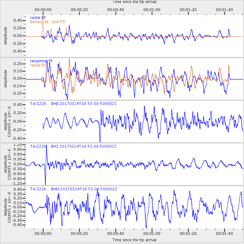
G22K Bettles, AK, USA - Earthquake Result Viewer
*The percent match for this event was below the threshold and hence no stack was calculated.
| Earthquake location: |
Ryukyu Islands, Japan |
| Earthquake latitude/longitude: |
26.9/127.2 |
| Earthquake time(UTC): |
2017/03/24 (083) 16:43:27 GMT |
| Earthquake Depth: |
77 km |
| Earthquake Magnitude: |
5.1 Mww |
| Earthquake Catalog/Contributor: |
NEIC PDE/us |
|
| Network: |
TA USArray Transportable Network (new EarthScope stations) |
| Station: |
G22K Bettles, AK, USA |
| Lat/Lon: |
66.92 N/151.51 W |
| Elevation: |
205 m |
|
| Distance: |
62.2 deg |
| Az: |
26.145 deg |
| Baz: |
273.423 deg |
| Ray Param: |
$rayparam |
*The percent match for this event was below the threshold and hence was not used in the summary stack. |
|
| Radial Match: |
57.3926 % |
| Radial Bump: |
400 |
| Transverse Match: |
61.541523 % |
| Transverse Bump: |
400 |
| SOD ConfigId: |
11737051 |
| Insert Time: |
2019-04-26 23:32:55.560 +0000 |
| GWidth: |
2.5 |
| Max Bumps: |
400 |
| Tol: |
0.001 |
|
Signal To Noise
| Channel | StoN | STA | LTA |
| TA:G22K: :BHZ:20170324T16:53:09.500002Z | 3.9620535 | 3.8344078E-7 | 9.6778294E-8 |
| TA:G22K: :BHN:20170324T16:53:09.500002Z | 1.4545444 | 1.4354423E-7 | 9.8686726E-8 |
| TA:G22K: :BHE:20170324T16:53:09.500002Z | 1.7255766 | 1.4814096E-7 | 8.585012E-8 |
| Arrivals |
| Ps | |
| PpPs | |
| PsPs/PpSs | |


