You are here: Home > Network List > TA - USArray Transportable Network (new EarthScope stations) Stations List
> Station G23K Bananza Creek, AK, USA > Earthquake Result Viewer
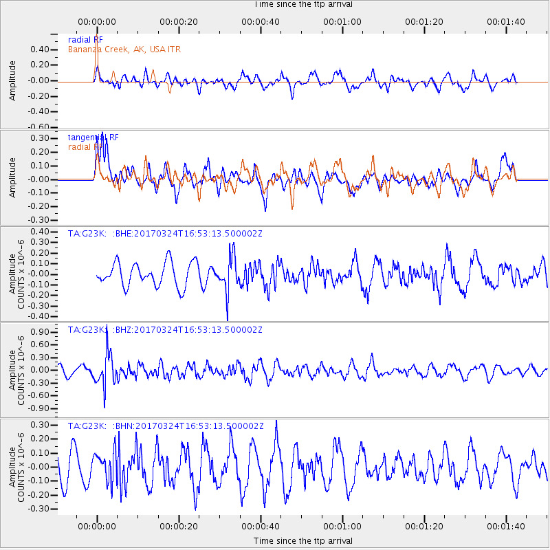
G23K Bananza Creek, AK, USA - Earthquake Result Viewer
*The percent match for this event was below the threshold and hence no stack was calculated.
| Earthquake location: |
Ryukyu Islands, Japan |
| Earthquake latitude/longitude: |
26.9/127.2 |
| Earthquake time(UTC): |
2017/03/24 (083) 16:43:27 GMT |
| Earthquake Depth: |
77 km |
| Earthquake Magnitude: |
5.1 Mww |
| Earthquake Catalog/Contributor: |
NEIC PDE/us |
|
| Network: |
TA USArray Transportable Network (new EarthScope stations) |
| Station: |
G23K Bananza Creek, AK, USA |
| Lat/Lon: |
66.71 N/150.02 W |
| Elevation: |
746 m |
|
| Distance: |
62.8 deg |
| Az: |
26.335 deg |
| Baz: |
274.873 deg |
| Ray Param: |
$rayparam |
*The percent match for this event was below the threshold and hence was not used in the summary stack. |
|
| Radial Match: |
53.047863 % |
| Radial Bump: |
400 |
| Transverse Match: |
62.64033 % |
| Transverse Bump: |
400 |
| SOD ConfigId: |
11737051 |
| Insert Time: |
2019-04-26 23:32:56.215 +0000 |
| GWidth: |
2.5 |
| Max Bumps: |
400 |
| Tol: |
0.001 |
|
Signal To Noise
| Channel | StoN | STA | LTA |
| TA:G23K: :BHZ:20170324T16:53:13.500002Z | 3.1890066 | 3.903659E-7 | 1.2240987E-7 |
| TA:G23K: :BHN:20170324T16:53:13.500002Z | 0.8332441 | 1.0071061E-7 | 1.2086568E-7 |
| TA:G23K: :BHE:20170324T16:53:13.500002Z | 1.4763923 | 1.6378695E-7 | 1.10937286E-7 |
| Arrivals |
| Ps | |
| PpPs | |
| PsPs/PpSs | |


